Tag - scenery

Heron Pond / Swan Lake Loop 16

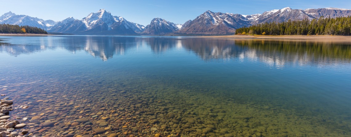
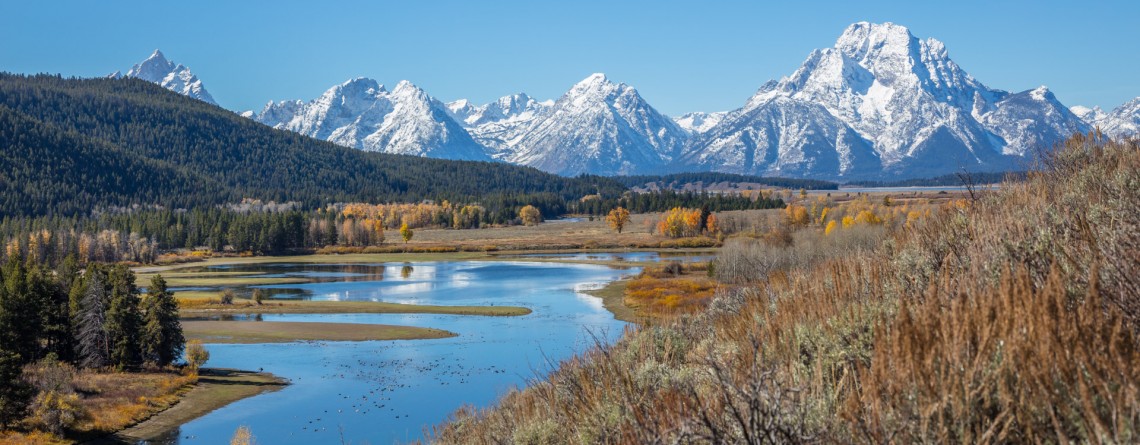
Heron Pond / Swan Lake Loop Trail of Grand Teton National Park

    Location: Grand Teton National Park, Wyoming Length: 3 miles Difficulty: Easy Elevation gain: 300 feet GPS coordinates: N 43 54.031   W 110 38.533   Grand Teton National Park is special among all US national parks. Most of its rivers and lakes got their names as a result of expeditions in 1872. It is also the only national park of all, where there is an airport. The numerous lakes of the park attract a great diversity of waterfowl, and the height and beauty of its [...]

Christian Pond Loop 17

Amazing autumn scenery of Christian Pond Loop

  Location: Grand Teton National Park, Wyoming Length: 3,3 miles Difficulty: Easy Elevation gain: 400 feet GPS coordinates: N 43 52.691   W 110 34.363 Grand Teton National Park - a speck of untouched pristine nature just south of Yellowstone National Park, in northwest Wyoming. The park is well-known and beloved by tourists for its fascinating views of the mountains, shimmering of pure alpine lakes and abundant wildlife. Its highest peak, Grand Teton, rises up to almost 14,000 feet a.s.l. and the park spreads over [...]

The Watchman Trail 6

Unforgettable Views of the Watchman Trail

Location: Zion National Park, Utah Length: 3 miles (with the loop at the end of the trail) Ascent: 300 feet Difficulty: Easy GPS Coordinates:  N 37 12.083   W 112 59.186   The start of this 3-mile long trail can be found near the Visitor’s Center, you just need to cross the Route 9 to find yourself at its trailhead. It is interesting that regardless of its proximity to Park’s South Entrance, this trail is missed by lots of visitors, who prefer more popular routes like [...]

Island in Time Trail 41

Island in Time Trail – a harkback to the past

  Location: Sheep Rock Unit, John Day Fossil Beds National Monument, Oregon Roundtrip: 1,3 mile Difficulty: Easy Elevation Gain: 220 feet GPS Coordinates: N 44 35.730 W 119 37.856 Visitor’s Information Open: all year round No Pass Required   Blue Basin is an incredible and unparalleled area of John Day Fossil Beds National Monument. At first glance you see only the beauty and unicity of landscape, the enchantment of the colors, but when you look deeper, you understand the whole historical importance of this place. Its paleontological significance cannot be overestimated. Starting from 1860s, when Thomas [...]

Mt. Carmel Highway 15

Zion National Park and the Scenic Drive along Mt. Carmel Highway

  Location: Zion National Park, Utah Address: 1 Zion Park Blvd., State Route 9, Springdale, UT 84767 Phone: (435) 772-3256 GPS coordinates of Zion East Entrance: N 37 13.999 W 112 52.527   Nowadays it is hard to astonish a person with anything. People are satiated with information and colorful pictures. But Nature is a great architect, its imagination is simply inexhaustible, and every time it is able to delight the eyes of an investigative observer with something which makes you to freezes in awe and admiration. Do [...]

Misery Ridge Trail 24

Misery Ridge Trail at Smith Rock State Park

Address: Terrebonne, OR 97760, United States Phone number: 541-548-7501 Length: 0.68 miles GPS Coordinates: N 44 21.952 W 121 08.233 Information Center: Crooked River National Grassland, 274 SW 4th Street, Madras, OR Misery Ridge Trail is probably the most popular and well-known trail of the Rock Smith State Park, but for inexperienced hikers it may also seem one of the most strenuous trails of this state park. Its steep ascend at the beginning caused lots of troubles to early pioneers, trying to cross over the mountain [...]

Midway Geyser Basin 25

Midway Geyser Basin and Grand Prismatic Spring and Excelsior Geyser

Location: Yellowstone National Park, Lower Geyser Basin Length: 0.8 miles GPS Coordinates:  N 44 31.705 W 110 50.175 Midway Geyser Basin is a small area known for the two big geothermal features that are located here. The size of the basin is small, but its popularity was won by the Excelsior Geyser and Grand Prismatic Spring. The basin itself is a part of Lower Geyser Basin, but because of its location it received a name of the Midway Geyser Basin. Grand Prismatic Spring is [...]

Biscuit Basin 25

Biscuit Basin – Yellowstone National Park

Difficulty: Easy Length: 0.7 miles GPS Coordinates: N 44 29.103 W 110 51.153 Biscuit Basin is part of Upper Geyser Basin and is home for Mustard Spring, beautiful Sapphire Pool and Black Opal Pool, Shell Geyser, Avoca Spring, Jewel Geyser, etc. Biscuit Basic is located at Yellowstone National Park, only 3 miles from a very famous Old Faithful. The basin got its name thanks to the deposits, biscuit-shaped, that were found on the territory around Sapphire Pool. On August 17, 1959 the earthquake [...]

Badwater Salt Flats 24

White Salt Flats of Badwater

Location: Death Valley National Park Length: 2 miles roundtrip GPS Coordinates: N 36 13.79 W 116 46.035 Contact Information: Death Valley National Park P.O. Box 579 Death Valley, CA 92328 Badwater Basin is an endorheic basin known as the lowest point in North America. Its elevation is 282 ft below sea level. The name to the area was given thanks to the spring-fed pool of “bad water”, the salt make this water undrinkable. Actually, this water is four times saltier than the water in the ocean. Although, the water in [...]

Painted Hills Overlook Trail 14

The Best Views of the Painted Hills Overlook Trail

Location: Painted Hills Unit, John Day Fossil Beds National Monument, Oregon Round Trip: 0,5 miles Difficulty: Easy Elevation Gain: 100 feet GPS Coordinates: N 44 38.997 W 120 16.005 Visitor’s Information Open: all year round No Pass Required   One more option to enjoy some really scenic views of the Painted Hills and get the most out of this incredible area is hiking the Painted Hills Overlook Trail. It’s much shorter than the Carroll Rim Trail, but the fabulous views it opens for its visitors are highly competitive with those of the Carroll [...]

Carroll Rim Trail 64

The surreal views of the Carroll Rim Trail

Location: Painted Hills Unit, John Day Fossil Beds National Monument, Oregon Round Trip: 1,6 miles Difficulty: Moderate Elevation Gain: 400 feet GPS Coordinates: N 44 39.117 W 120 16.042 Visitor’s Information Open: all year round No Pass Required The Painted Hills Unit is one of three parts /units of the John Day Fossil Beds National Monument. And if the Clarno Unit is one of the most remote and the least visited one, the Painted Hills Unit is the most beautiful part of the National Monument. You don’t need to be scientist interested [...]

Lady Bird Johnson Grove 8

Lady Bird Johnson Grove

Location: Redwood National Park, California Round Trip: 1,4 miles loop Difficulty: Easy Elevation Gain: 100 feet GPS Coordinates: N 41 18.209 W 124 01.079 Visitor’s Information Open: all year round No Pass Required Redwood National Park has quite a number of fantastic groves. One of the most popular among them is Lady Bird Johnson Gove as it’s not only an impressive natural feature of the park, but also a historical place. The Lady Bird Johnson trail was created for the ceremony of Redwoods National Park dedication, which happened on August 27, 1969. Many [...]

South Kaibab Trail

Location: Grand Canyon, South Rim Round Trip: 14 miles Difficulty: Strenuous Elevation Change: 4,780 feet Highest Point At the trailhead – 7,260 feet GPS Coordinates: N 36 3.177 W 112 5.038 Visitor’s Information Open: all year round No Pass Required   South Rim, being the most popular among the rims and considered the most beautiful one, has a lot of attractions and many trails to offer to its visitors. Most of the tourists prefer to enjoy the beauty and majesty of the Grand Canyon from its edge, but we are sure that the real greatness [...]