Tag - amazing views

Clatsop Loop Trail 1

CLATSOP LOOP TRAIL

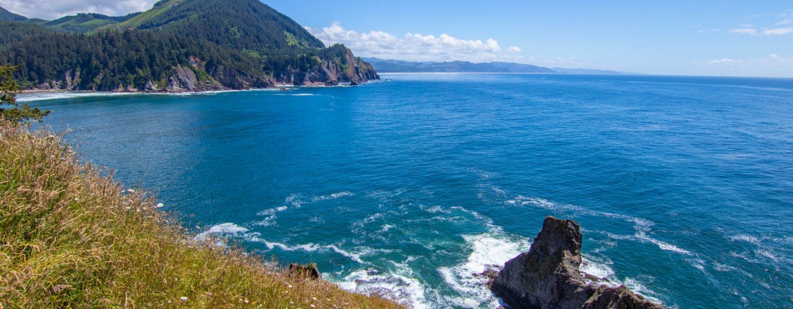
  Location: Ecola State Park, Oregon Length: 2,7 miles Difficulty: Moderate Elevation gain: 720 feet GPS coordinates: N 45 55.905  W 123 58.749 Take in the atmosphere of tranquility and peace while hiking along the Clatsop loop trail. Take a journey through the fascinating old growth forest and soak up the gorgeous views of the ocean. Clatsop loop trail is 2.7 mile trail which begins at the Indian Beach parking area in Ecola State Park. It's a dog friendly quick loop trail that will reward you [...]

Sonoma Coast State Park 27

Sonoma Coast State Park – an incredible place you’ll never forget

  Address: 3095 Highway 1 Bodega Bay, CA 94923 Phone: (707) 875-3483 Acreage: 10,000 GPS Coordinates: N 38 24.310 W 123 05.867 If you want to enjoy the fullness of beauty and uniqueness of the northern Californian Coast, Sonoma Coast State Park is just the right place for this. Spreading out its land of more than 10,000 acres on the 17 miles of Pacific coastline, this park boasts breathtaking scenery of the majestic ocean and incredible beaches which are quite diverse in their appearance. [...]

Kortum Trail 17

Kortum Trail – enjoy the beauty of the Pacific Coastline

  Location: Sonoma Coast State Park, California Length: 8 miles (roundtrip) Difficulty: Easy Elevation Gain: 300 feet (at the northern section, going from Shell Beach to Goat Rock) GPS Coordinates: N 38 24.310 W 123 05.867 Kortum Trail is the best option to get acquainted with the “coastal part” of Sonoma Coast State Park. Being the longest trail of the park, it runs for about 4 miles from the Wright’s Beach on the south up to the Blind Beach on the north. The trail was [...]

Heron Pond / Swan Lake Loop 16

Heron Pond / Swan Lake Loop Trail of Grand Teton National Park

    Location: Grand Teton National Park, Wyoming Length: 3 miles Difficulty: Easy Elevation gain: 300 feet GPS coordinates: N 43 54.031   W 110 38.533   Grand Teton National Park is special among all US national parks. Most of its rivers and lakes got their names as a result of expeditions in 1872. It is also the only national park of all, where there is an airport. The numerous lakes of the park attract a great diversity of waterfowl, and the height and beauty of its [...]

Christian Pond Loop 17

Amazing autumn scenery of Christian Pond Loop

  Location: Grand Teton National Park, Wyoming Length: 3,3 miles Difficulty: Easy Elevation gain: 400 feet GPS coordinates: N 43 52.691   W 110 34.363 Grand Teton National Park - a speck of untouched pristine nature just south of Yellowstone National Park, in northwest Wyoming. The park is well-known and beloved by tourists for its fascinating views of the mountains, shimmering of pure alpine lakes and abundant wildlife. Its highest peak, Grand Teton, rises up to almost 14,000 feet a.s.l. and the park spreads over [...]

The Watchman Trail 6

Unforgettable Views of the Watchman Trail

Location: Zion National Park, Utah Length: 3 miles (with the loop at the end of the trail) Ascent: 300 feet Difficulty: Easy GPS Coordinates:  N 37 12.083   W 112 59.186   The start of this 3-mile long trail can be found near the Visitor’s Center, you just need to cross the Route 9 to find yourself at its trailhead. It is interesting that regardless of its proximity to Park’s South Entrance, this trail is missed by lots of visitors, who prefer more popular routes like [...]

Story in Stone Trail 24

Story in Stone Trail

  Location: Sheep Rock Unit, John Day Fossil Beds National Monument, Oregon Roundtrip: 1/3 mile Difficulty: Easy Elevation Gain: 40 feet GPS Coordinates: N 44 39.126   W 119 38.407 Visitor’s Information Open: all year round No Pass Required   Foree Area is the northernmost section of Sheep Rock Unit, separated by some private lands from the main part of the Unit. The main tourist features of this area, except for the magnificent scenery of course, is a modest picnic area and two hiking trails – the Flood of Fire Trail and the Story in Stone Trail. Sharing [...]

Flood of Fire Trail 18

The beauty of Foree Area from the Flood of Fire Trail

    Location: Sheep Rock Unit, John Day Fossil Beds National Monument, Oregon Roundtrip: 0,4 mile Difficulty: Easy Elevation Gain: 50 feet GPS Coordinates: N 44 39.147   W 119 38.434 Visitor’s Information Open: all year round No Pass Required   Foree area is a part of the Sheep Rock Unit, but is located at some distance northwards from the rest of the Unit. You need to drive a little bit more than 7 miles north on Highway 19 from the Paleontology Center until you reach the right turn with the sign indicating the Picnic Area. [...]

Blue Basin Overlook Trail 8

Blue Basin Overlook Trail of the Sheep Rock Unit

    Location: Sheep Rock Unit, John Day Fossil Beds National Monument, Oregon Roundtrip: 3,25 miles loop-trail Difficulty: Moderate Elevation Gain: 760 feet GPS Coordinates: N 44 35.730 W 119 37.856 Visitor’s Information Open: all year round No Pass Required   John Day Fossil Beds National Monument in Oregon can become a decoration of any journey. It's like a trip in a time machine to the distant past of the planet. And if you have interest in paleontology, it is definitely worth a look, although this national monument is located away from the beaten tourist trails, [...]

River Trail 42

Cant Ranch and a peacefully beautiful River Trail

  Location: Sheep Rock Unit, John Day Fossil Beds National Monument, Oregon Roundtrip: 0,6 miles Difficulty: Easy Elevation Gain: None GPS Coordinates: N 44 33.334   W 119 38.677 Visitor’s Information Open: all year round No Pass Required   Cant Ranch is the second “must-visit” place on your trip around the Sheep Rock Unit after Paleontology Center. It can be easily found as it is situated just across the street from the Center. The former house of Scottish immigrants - James Cant and his wife Elizabeth, which was built in 1917, serves now as a historical [...]

Thomas Condon Overlook Trail 19

The beauty of John Day River valley as seen from Thomas Condon Overlook Trail

  Location: Sheep Rock Unit, John Day Fossil Beds National Monument, Oregon Roundtrip: 0,25 miles Difficulty: Easy Elevation Gain: 40 feet GPS Coordinates: N 44 33.101   W 119 38.759 Visitor’s Information Open: all year round No Pass Required   If you chose John Day Fossil Beds (JDFB) National Monument as your next trip destination, you may plan the exploration of this unique source of geologic history study starting from any of 3 units, it is made-up of (Clarno Unit, Painted Hills Unit, Sheep Rock Unit). But to our opinion the best way to start [...]

Virgin River 13

Virgin River – a Beautiful Creator of Zion Canyon

  Many thousands of years ago, the Virgin River was making its way to the south, winding in the soft formations of a young Colorado Plateau. Over time, the plateau began to rise, driven by the powerful forces of Earth, and little river had to fight its way through it, "biting" into the rock and washing away particles of gravel and sand "on the way". Thus, thanks to the perseverance and persistence of the Virgin River an amazingly beautiful canyon [...]

Mt. Carmel Highway 15

Zion National Park and the Scenic Drive along Mt. Carmel Highway

  Location: Zion National Park, Utah Address: 1 Zion Park Blvd., State Route 9, Springdale, UT 84767 Phone: (435) 772-3256 GPS coordinates of Zion East Entrance: N 37 13.999 W 112 52.527   Nowadays it is hard to astonish a person with anything. People are satiated with information and colorful pictures. But Nature is a great architect, its imagination is simply inexhaustible, and every time it is able to delight the eyes of an investigative observer with something which makes you to freezes in awe and admiration. Do [...]