Tag - 4k photography

Sonoma Coast State Park 27

Sonoma Coast State Park – an incredible place you’ll never forget

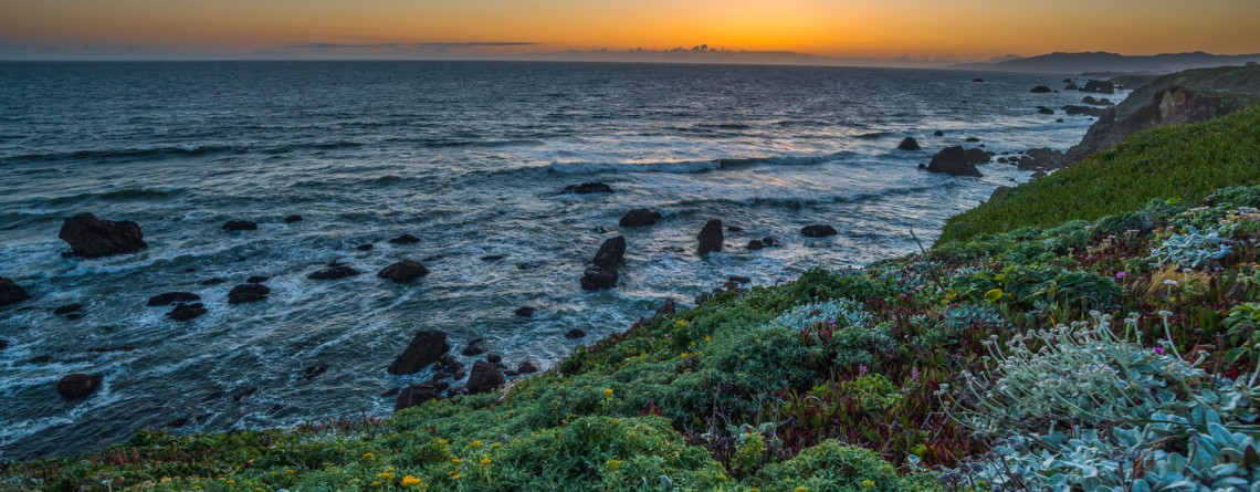
  Address: 3095 Highway 1 Bodega Bay, CA 94923 Phone: (707) 875-3483 Acreage: 10,000 GPS Coordinates: N 38 24.310 W 123 05.867 If you want to enjoy the fullness of beauty and uniqueness of the northern Californian Coast, Sonoma Coast State Park is just the right place for this. Spreading out its land of more than 10,000 acres on the 17 miles of Pacific coastline, this park boasts breathtaking scenery of the majestic ocean and incredible beaches which are quite diverse in their appearance. [...]

Jedediah Smith Redwoods State Park Campground 5

Jedediah Smith Redwoods State Park Campground

  Location: Jedediah Smith Redwoods State Park, California Address: 1111 Second Street, Crescent City, CA 95531 Phone for reservation: 800-444-7275  or at website of Reserve America Open Season: Year round (high season May 15th – September 30th) Vehicle Length Limit: 36-foot RV or 31-foot trailer GPS Coordinates: N 41 47.884 W 124 05.074 While exploring an outstanding JSRSP don’t miss a chance to spend a night under the canopy of the incredible gigantic redwood trees for the abundance of which this park is famous. Jedediah Smith Redwoods [...]

Hatton Trail 22

An amazing diversity of woodland shown by the Hatton Trail

  Location: Jedediah Smith Redwoods State Park, California Length: 4,3 miles Difficulty: Moderate Elevation gain: 360 feet GPS coordinates: N 41 48.692 W124 06.388 The Hatton Trail is one of the well-favoured routes giving a chance to explore Jedediah Smith Redwoods State Park. Moreover, this is three-in-one trail described here, as it combines the Hatton Loop, the Hatton Trail itself and a short spur-trail to Lohse Grove. The trail is located on the southern side of Highway 199, and can be accessed from two flanks: you may [...]

Heron Pond / Swan Lake Loop 16

Heron Pond / Swan Lake Loop Trail of Grand Teton National Park

    Location: Grand Teton National Park, Wyoming Length: 3 miles Difficulty: Easy Elevation gain: 300 feet GPS coordinates: N 43 54.031   W 110 38.533   Grand Teton National Park is special among all US national parks. Most of its rivers and lakes got their names as a result of expeditions in 1872. It is also the only national park of all, where there is an airport. The numerous lakes of the park attract a great diversity of waterfowl, and the height and beauty of its [...]

Twenty Mule Team Canyon Road 24

Scenic Drive along 20 Mule Team Canyon Road

  Location: Death Valley National Park, CA Length: 2,8 miles GPS Coordinates: N 36 24.570  W 116 47.680 Contact Information: Death Valley National Park P.O. Box 579 Death Valley, CA 92328   One of the best-known “historic symbols” of Death Valley is the Twenty Mule Teams. Such “teams” were comprised of 18 mules and 2 horses, pulling huge wagons filled with borax, bringing it from mines located in Furnace Creek area to the railhead which was at that time near Mojave. That was an exhausting trip which lasted for 10 days, [...]

Island in Time Trail 41

Island in Time Trail – a harkback to the past

  Location: Sheep Rock Unit, John Day Fossil Beds National Monument, Oregon Roundtrip: 1,3 mile Difficulty: Easy Elevation Gain: 220 feet GPS Coordinates: N 44 35.730 W 119 37.856 Visitor’s Information Open: all year round No Pass Required   Blue Basin is an incredible and unparalleled area of John Day Fossil Beds National Monument. At first glance you see only the beauty and unicity of landscape, the enchantment of the colors, but when you look deeper, you understand the whole historical importance of this place. Its paleontological significance cannot be overestimated. Starting from 1860s, when Thomas [...]

Blue Basin Overlook Trail 8

Blue Basin Overlook Trail of the Sheep Rock Unit

    Location: Sheep Rock Unit, John Day Fossil Beds National Monument, Oregon Roundtrip: 3,25 miles loop-trail Difficulty: Moderate Elevation Gain: 760 feet GPS Coordinates: N 44 35.730 W 119 37.856 Visitor’s Information Open: all year round No Pass Required   John Day Fossil Beds National Monument in Oregon can become a decoration of any journey. It's like a trip in a time machine to the distant past of the planet. And if you have interest in paleontology, it is definitely worth a look, although this national monument is located away from the beaten tourist trails, [...]

The Narrows 10

The Narrows – an incredibly unique experience for any hiker!

Location: Zion National Park, Utah Length: as long as you wish Difficulty: Moderate GPS Coordinates: N 37 17.798  W 112 56.895   Zion Narrows is among the most incredible and breathtaking adventures in the US. Thousands of people come to Zion National Park in order to challenge themselves with this scenic and adventurous hike. This unique hike at the bottom of a sandstone canyon, the walls of which rise thousands of feet vertically and come as close as twenty feet across at some places is [...]

East Mesa Trail 11

East Mesa Trail (going to Observation Point)

  Location: Zion National Park, Utah Length: 3,3 miles (one way trip) Elevation Gain: 280 feet Difficulty: Moderate GPS Coordinates: N  37 17.819   W  112 54.013 Zion National Park has several overlooks providing the visitors with an amazing panorama of the park’s canyons. One of them is Observation Point, situated at the Eastern Rim of Zion Canyon, at elevation of approximately 6,500 feet. The usual starting point for the hikers, willing to reach Observation Point, is the Weeping Rock Trailhead, which is actually the start [...]

Virgin River 13

Virgin River – a Beautiful Creator of Zion Canyon

  Many thousands of years ago, the Virgin River was making its way to the south, winding in the soft formations of a young Colorado Plateau. Over time, the plateau began to rise, driven by the powerful forces of Earth, and little river had to fight its way through it, "biting" into the rock and washing away particles of gravel and sand "on the way". Thus, thanks to the perseverance and persistence of the Virgin River an amazingly beautiful canyon [...]

Mt. Carmel Highway 15

Zion National Park and the Scenic Drive along Mt. Carmel Highway

  Location: Zion National Park, Utah Address: 1 Zion Park Blvd., State Route 9, Springdale, UT 84767 Phone: (435) 772-3256 GPS coordinates of Zion East Entrance: N 37 13.999 W 112 52.527   Nowadays it is hard to astonish a person with anything. People are satiated with information and colorful pictures. But Nature is a great architect, its imagination is simply inexhaustible, and every time it is able to delight the eyes of an investigative observer with something which makes you to freezes in awe and admiration. Do [...]

Riverside Walk Trail 24

Riverside Walk Trail at Zion National Park

  Location: Zion National Park, Utah Length: 2 miles roundtrip Ascent: 57 feet Difficulty: Easy GPS Coordinates: N 37 17.058 W 112 56.811 The Riverside Walk Trail is an outstanding and fascinating trek in Zion National Park, presenting for the park visitors the breathtaking views of immense stone walls of Zion Canyon as seen from its very bottom, and marvelous views of the Virgin River, flowing along the trail. It’s amazing but the quantity of the trail visitors in summer months reaches three thousand per [...]

Sand Bench Horse Trail 22

Sand Bench Trail – the underestimated gem of Zion National Park

Location: Zion National Park, Utah Length: 3,5 mile Elevation gain: 440 feet GPS coordinates: N 37 14.239 W 112 57.745 The Sand Bench Horse Trail is one of the trails of Zion National Park, which probably has the most contradictory reviews of the visitors who decided to explore it. The beauty and uniqueness of the views offered by this trail is undeniable. Approximately seven thousand years have passed since a part of one of the most famous Zion peaks – The Sentinel – collapsed, [...]