Tag - Nature

Old Faithful Geyser 2

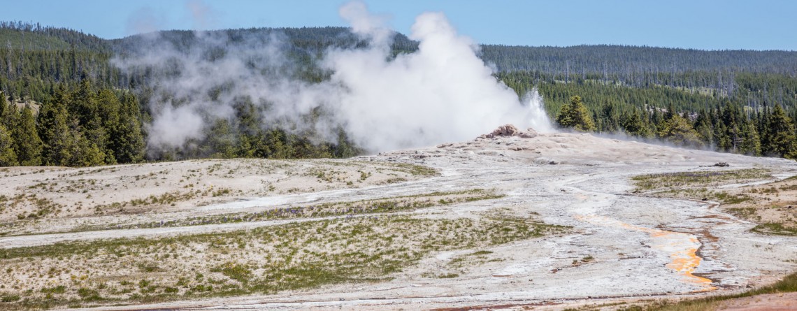
Old Faithful Geyser – Is it really so faithful?

Location: Upper Geyser Basin, Yellowstone National Park GPS Coordinates: N 44 27.635 W 110 49.846 The Upper Geyser Basin in Yellowstone National Park is home for one of the most famous and faithful geysers in the world. This basin is famous for the fact that nearly one quarter of all worlds’ geysers is located here. Just imagine a territory in one square mile that has 150 geysers. Not only geysers, but also such thermal features like hot springs, boiling springs and [...]

Mesquite Falls Sand Dunes 46

Unusual Mesquite Flat Sand Dunes – Death Valley National Park

Location: Death Valley National Park Length: No trail GPS Coordinates: N 36 36.372 W 117 6.904 Contact Information: Death Valley National Park P.O. Box 579 Death Valley, CA 92328 Mesquite Flat Sand Dunes are beautiful and the most accessible sand dunes in Death Valley. Though they are not the tallest, they are very popular among tourists. The largest dune is called Star Dune. The highest dune rises about 100 feet, but these dunes cover massive territory, but it’s only one percent of the Death Valley that is covered with [...]

Golden Canyon 53

Vibrant colors at Golden Canyon

Location: Death Valley National Park Length: 2 miles roundtrip GPS Coordinates: N 36 25.24 W 116 50.812 Contact Information: Death Valley National Park P.O. Box 579 Death Valley, CA 92328 Golden Canyon is an easy hike, it can be only a 2-mile hike (roundtrip) to Red Cathedral Junction, or the hike can be longer, if you decide to continue to Gower Gulch or even Zabriskie Point. Very often tourists ask when the best time to hike Death Valley National Park is. We recommend hiking between October and April. Even in [...]

Badwater Salt Flats 24

White Salt Flats of Badwater

Location: Death Valley National Park Length: 2 miles roundtrip GPS Coordinates: N 36 13.79 W 116 46.035 Contact Information: Death Valley National Park P.O. Box 579 Death Valley, CA 92328 Badwater Basin is an endorheic basin known as the lowest point in North America. Its elevation is 282 ft below sea level. The name to the area was given thanks to the spring-fed pool of “bad water”, the salt make this water undrinkable. Actually, this water is four times saltier than the water in the ocean. Although, the water in [...]

Coastal Trail, Hidden Beach Section 34

The Coastal Trail (Hidden Beach Section)

Location: Redwood National Park, California Round Trip: 7,8 miles Difficulty: Moderate Elevation Gain: 600 feet GPS Coordinates: N 41 35.632 W 124 05.913 Visitor’s Information Open: all year round No Pass Required   Worldwide known ancient redwood forests are not the only attraction the Redwood National and State Parks may offer to its visitors. A seventy-mile Coastal Trail provides the visitors with a change in redwoods hiking experience. It takes the hikers through the splendid coastal bluffs and solitary beaches of the Pacific coastline, opening for them amazing marine landscapes. And the most fascinating [...]

Skunk Cabbage Trail 15

Splendid Views of the Skunk Cabbage Trail

Location: Redwood National Park, California Round Trip: 10,5 miles Difficulty: Moderate Elevation Gain: 500 feet GPS Coordinates: N 41 35.671 W 124 05.981 Visitor’s Information Open: all year round No Pass Required Redwood National and State Parks are well-known among the tourists for the ancient redwood trees and magnificent forests, but the Coastal Trail, which occupies about 70 miles area, provides the hikers with a diverse experience. The Coastal Trail consists of a number of sections. The Skunk Cabbage Section (the Skunk Cabbage Trail) is one of them. The Skunk Cabbage Trail offers [...]

West Ridge and Prairie Creek Trail 12

West Ridge and Prairie Creek Trail

Location: Prairie Creek Redwoods State Park, California Round Trip: 5,8 miles loop Difficulty: Moderate Elevation Gain: 750 feet GPS Coordinates: N 41 21.828 W 124 01.374 Visitor’s Information Open: year-round, except when Drury Parkway is temporary closed because of heavy winter storms Day-use fees are collected at campground entrance stations. Prairie Creek Redwoods State Park is a fantastic sanctuary of 14,000 acres of redwood forests which owns the most scenic views among all the parks of Redwood National and State Parks system. It joins in itself two seemingly incompatible things: comprising magnificent [...]

Berry Glen Trail 22

Falling in love: Berry Glen Trail, Redwood National and State Parks

Location: Redwood National Park, California Round Trip: 6 miles Difficulty: Moderate Elevation Gain: 1200 feet GPS Coordinates: N 41 19.440 W 124 02.621 Visitor’s Information No Pass Required The Berry Glen Trail is one of the newest elements of the Redwood National Park. Being opened in October, 2010, this trail is the first one built in the Redwood National Park within the last decade. Its creation became possible thanks to the help of the Civilian Conservation Corps. Now this well-built and well-maintained three-mile trail connects the Elk Meadow Day Use Area, [...]

Bright Angel Point Trail 26

Unforgettable hike along Bright Angel Point Trail

Location: Grand Canyon, North Rim Round Trip: 0,5 miles Difficulty: Moderate Elevation Gain: 200 feet Highest Point: 8,148 feet GPS Coordinates: N 36 11.821 W 112 3.177 Visitor’s Information: Open mid. May – October, No Pass Required Bright Angel point is considered to be the most popular viewpoint among the visitors of the North Rim. A part of its popularity was earned, of course, due to its location. The trailhead or the Bright Angel Point Trail, leading to the viewing area, can be found just behind [...]