Tag - Trail

Biscuit Basin 25

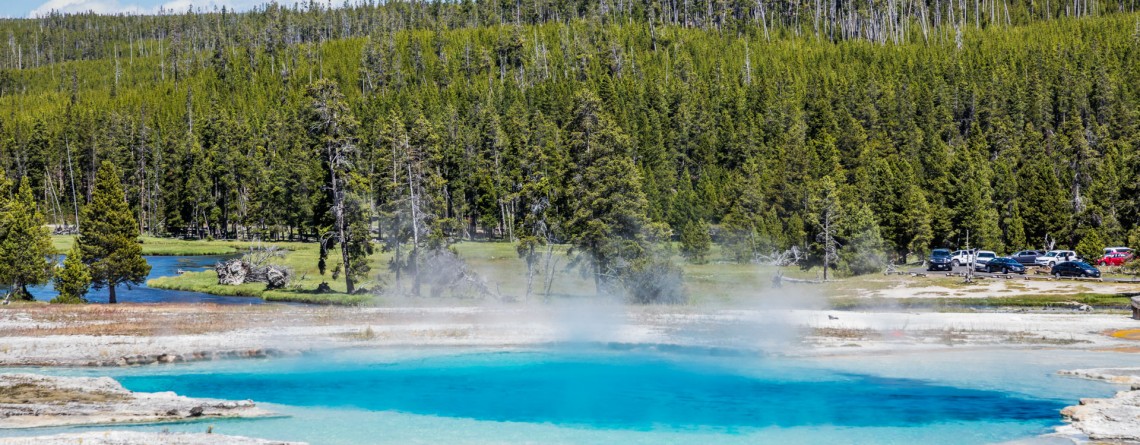
Biscuit Basin – Yellowstone National Park

Difficulty: Easy Length: 0.7 miles GPS Coordinates: N 44 29.103 W 110 51.153 Biscuit Basin is part of Upper Geyser Basin and is home for Mustard Spring, beautiful Sapphire Pool and Black Opal Pool, Shell Geyser, Avoca Spring, Jewel Geyser, etc. Biscuit Basic is located at Yellowstone National Park, only 3 miles from a very famous Old Faithful. The basin got its name thanks to the deposits, biscuit-shaped, that were found on the territory around Sapphire Pool. On August 17, 1959 the earthquake [...]

Mesquite Falls Sand Dunes 46

Unusual Mesquite Flat Sand Dunes – Death Valley National Park

Location: Death Valley National Park Length: No trail GPS Coordinates: N 36 36.372 W 117 6.904 Contact Information: Death Valley National Park P.O. Box 579 Death Valley, CA 92328 Mesquite Flat Sand Dunes are beautiful and the most accessible sand dunes in Death Valley. Though they are not the tallest, they are very popular among tourists. The largest dune is called Star Dune. The highest dune rises about 100 feet, but these dunes cover massive territory, but it’s only one percent of the Death Valley that is covered with [...]

Badwater Salt Flats 24

White Salt Flats of Badwater

Location: Death Valley National Park Length: 2 miles roundtrip GPS Coordinates: N 36 13.79 W 116 46.035 Contact Information: Death Valley National Park P.O. Box 579 Death Valley, CA 92328 Badwater Basin is an endorheic basin known as the lowest point in North America. Its elevation is 282 ft below sea level. The name to the area was given thanks to the spring-fed pool of “bad water”, the salt make this water undrinkable. Actually, this water is four times saltier than the water in the ocean. Although, the water in [...]

Bright Angel Trail, South Rim 68

Bright Angel Trail – the Premiere Trail of the Grand Canyon

Location: Grand Canyon, South Rim Round Trip: 19 miles Difficulty: Strenuous Elevation Change: 4,380 feet Highest Point: 6,860 feet (at the trailhead) GPS Coordinates: N 36 3.432 W 112 8.623 Visitor’s Information All year round   The Bright Angel Trail is one of the three trails of the Grand Canyon, which lead to the very Colorado River. Two others are the South Kaibab Trail and the North Kaibab Trail. But the Bright Angel Trail is considered to be in the greatest demand and is the most heavily used trail of the Grand Canyon. And [...]

Trillium Falls Trail 9

Trillium Falls Trail – a real gem of the Redwood National Park

Location: Redwood National Park, California Round Trip: 2,8 miles loop Difficulty: Moderate Elevation Gain: 400 feet GPS Coordinates: N 41 19.440 W 124 02.621 Visitor’s Information Open: all year round No Pass Required The Trillium Falls Trail is one of the most popular trails in the Redwood National Park, and that is not only due to an easy access to it, but also to the features it is offering to its visitors. This 2,8 miles loop, which is one of the newest trails in the Park (finished in 2002) will take you [...]

North Kaibab Trail 12

Meeting the North Rim – North Kaibab Trail

Location: Grand Canyon, North Rim Round Trip: 28 miles Difficulty: Strenuous Elevation Change: 5,760 feet Highest Point: 8,241 feet (at the trailhead) GPS Coordinates: N 36 13.023 W 112 3.414 Visitor’s Information Open: mid. May – mid. October Planning to visit the Grand Canyon, you’ll have to decide first from which Rim to experience this breathtaking natural feature of Arizona State: South Rim, West Rim or North Rim. The North Rim is considered the least popular among tourists and hikers, but the reason for this is not the lack of picturesque views, scenic [...]

South Rim Viewpoints 103

South Rim Viewpoints

Location:    Grand Canyon, South Rim GPS Coordinates:    N 36 3.558 W 112 6.581 Visitors Information:    No Fee Required The gorgeous South Rim has so much to offer to its visitors. Basing on what you feel interest in, there are many options of exploring the Grand Canyon from the South Rim. It has totally about 50 viewpoints opening for the visitors magnificent vistas of the canyon (and these are only named viewpoints, without regard to various unnamed pull-outs and viewpoints). Some of [...]

Cape Royal Trail 12

Cape Royal Trail / North Rim

Location: Grand Canyon, North Rim Round Trip: 0,6 miles GPS Coordinates: N 36 7.339 W 111 56.968 Being less popular among the tourists because of its location, North Rim has so much more to offer its visitors than the South Rim. According the statistics only 10% of the total number of tourists is going to the North Rim. And even less visitors have enough patience to get to its southern end – to Cape Royal. And we may understand why it is so. [...]