US National Parks

The amazing beauty of nature, its uniqueness and wilderness is now preserved by the government in various parks, recreation areas, nature reserves and wildlife refuges.

Devil's Golf Course 18

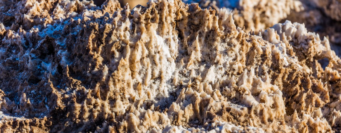
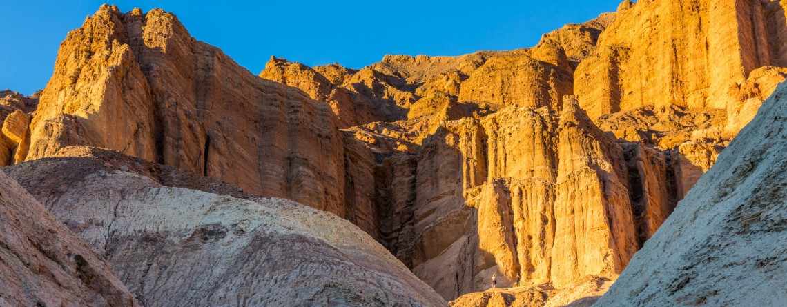
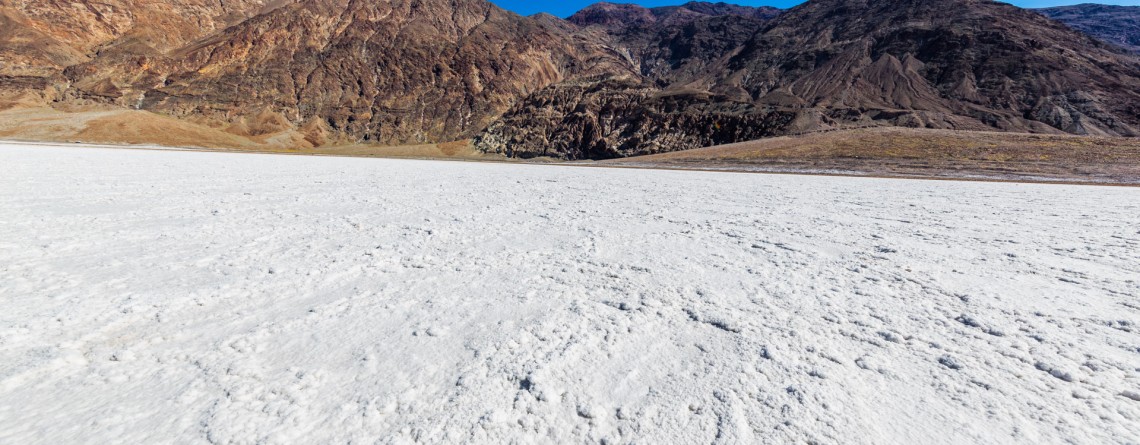
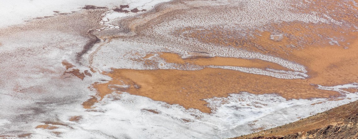
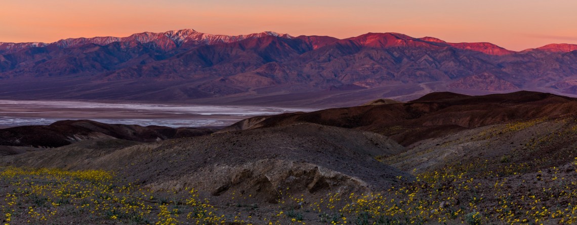
Devil’s Golf Course – Alien Views and Landscape

Location: Death Valley National Park Length: It can be as long as you want (there is no a designated trail) GPS Coordinates: N 36 17.157 W 116 49.567 Contact Information: Death Valley National Park P.O. Box 579 Death Valley, CA 92328 The Devil’s Golf Course is a fabulously beautiful and large salt pan on the floor of Death Valley National Park. It is located in the Mojave Desert. This salt pen is a huge bed of a dried up Lake Manly that covered the territory of the valley. The [...]

Golden Canyon 53

Vibrant colors at Golden Canyon

Location: Death Valley National Park Length: 2 miles roundtrip GPS Coordinates: N 36 25.24 W 116 50.812 Contact Information: Death Valley National Park P.O. Box 579 Death Valley, CA 92328 Golden Canyon is an easy hike, it can be only a 2-mile hike (roundtrip) to Red Cathedral Junction, or the hike can be longer, if you decide to continue to Gower Gulch or even Zabriskie Point. Very often tourists ask when the best time to hike Death Valley National Park is. We recommend hiking between October and April. Even in [...]

Badwater Salt Flats 24

White Salt Flats of Badwater

Location: Death Valley National Park Length: 2 miles roundtrip GPS Coordinates: N 36 13.79 W 116 46.035 Contact Information: Death Valley National Park P.O. Box 579 Death Valley, CA 92328 Badwater Basin is an endorheic basin known as the lowest point in North America. Its elevation is 282 ft below sea level. The name to the area was given thanks to the spring-fed pool of “bad water”, the salt make this water undrinkable. Actually, this water is four times saltier than the water in the ocean. Although, the water in [...]

Natural Bridge Canyon Trail 17

Gorgeous Arch at Natural Bridge Canyon

Location: Death Valley National Park Length: 2 miles roundtrip GPS Coordinates: N 36 16.872 W 116 46.193 Natural Bridge Canyon Trail is one of the most popular in the Death Valley National Park. It is situated closely to Furnace Creek and is not very long. Only a 15-minute hike from the parking lot will take you to a 50-foot-high natural bridge. This arch is a result of erosion, and a great example of how it can create really huge holes in the stones. Natural Bridge Canyon [...]

Dante's View 23

Hiking around Death Valley: Dante’s View

Location: Death Valley National Park Elevation gain: 250-300 ft GPS Coordinates: N 36 13.238 W 116 43.584 Dante’s View is a fabulous overlook that is considered one of the best high elevations and easily-accessible viewpoints in California.  This viewpoint is situated at the edge of the Black Mountains and provides gorgeous views of southern part of Death Valley National Park. This place is considered to be one of the most photogenic places in the entire National Park. Thirteen-mile road leads you to Dante’s View, be prepared [...]

Artist's Drive 46

Unusual Color Palette: Artist’s Drive and Artist’s Palette

Location: Death Valley National Park Area: Furnace Creek GPS Coordinates:  N 36 19.798 W 116 49.792 Artist’s Drive, as well as famous Artist’s Palette, is located in the Black Mountains on the territory of Death Valley National Park. This is a scenic drive (one way road) that takes visitors through the colorful area. Artist’s Drive is a nine-mile road that travels from south to north. It ascends above the salt flat of Badwater and opens impressive, fabulous and unforgettable views. This road carves through the high [...]

Zabriskie Point 15

Dramatic views and geological history – Zabriskie Point, Death Valley National Park

Location:    Death Valley National Park, Furnace Creek Area Round Trip:    2.9 miles from Golden Canyon GPS Coordinates:    N 36 25.258 W 116 48.578 Death Valley National Park is a 3.4 million acre park that is the largest park in the contiguous states of the USA.  This unusual valley is surrounded by steep mountain ranges. There are the Panamint Mountains to the west, and the Black, Funeral, and Grapevine Mountains to the east. Its highest point is Telescope Peak, at 11,049 feet. Death Valley [...]

Bright Angel Trail, South Rim 68

Bright Angel Trail – the Premiere Trail of the Grand Canyon

Location: Grand Canyon, South Rim Round Trip: 19 miles Difficulty: Strenuous Elevation Change: 4,380 feet Highest Point: 6,860 feet (at the trailhead) GPS Coordinates: N 36 3.432 W 112 8.623 Visitor’s Information All year round   The Bright Angel Trail is one of the three trails of the Grand Canyon, which lead to the very Colorado River. Two others are the South Kaibab Trail and the North Kaibab Trail. But the Bright Angel Trail is considered to be in the greatest demand and is the most heavily used trail of the Grand Canyon. And [...]

Trillium Falls Trail 9

Trillium Falls Trail – a real gem of the Redwood National Park

Location: Redwood National Park, California Round Trip: 2,8 miles loop Difficulty: Moderate Elevation Gain: 400 feet GPS Coordinates: N 41 19.440 W 124 02.621 Visitor’s Information Open: all year round No Pass Required The Trillium Falls Trail is one of the most popular trails in the Redwood National Park, and that is not only due to an easy access to it, but also to the features it is offering to its visitors. This 2,8 miles loop, which is one of the newest trails in the Park (finished in 2002) will take you [...]

Coastal Trail, Hidden Beach Section 34

The Coastal Trail (Hidden Beach Section)

Location: Redwood National Park, California Round Trip: 7,8 miles Difficulty: Moderate Elevation Gain: 600 feet GPS Coordinates: N 41 35.632 W 124 05.913 Visitor’s Information Open: all year round No Pass Required   Worldwide known ancient redwood forests are not the only attraction the Redwood National and State Parks may offer to its visitors. A seventy-mile Coastal Trail provides the visitors with a change in redwoods hiking experience. It takes the hikers through the splendid coastal bluffs and solitary beaches of the Pacific coastline, opening for them amazing marine landscapes. And the most fascinating [...]

Skunk Cabbage Trail 15

Splendid Views of the Skunk Cabbage Trail

Location: Redwood National Park, California Round Trip: 10,5 miles Difficulty: Moderate Elevation Gain: 500 feet GPS Coordinates: N 41 35.671 W 124 05.981 Visitor’s Information Open: all year round No Pass Required Redwood National and State Parks are well-known among the tourists for the ancient redwood trees and magnificent forests, but the Coastal Trail, which occupies about 70 miles area, provides the hikers with a diverse experience. The Coastal Trail consists of a number of sections. The Skunk Cabbage Section (the Skunk Cabbage Trail) is one of them. The Skunk Cabbage Trail offers [...]

Emerald Ridge and Tall Trees 38

Emerald Ridge and Tall Trees Grove

Location: Redwood National Park, California Round Trip: 5,5 miles loop Difficulty: Moderate Elevation Gain: 700 feet GPS Coordinates: N 41 12.488 W 123 59.586 Visitor’s Information Open: only in summer during low water period Free permit is required for the gate The Tall Trees Grove is one of the most popular places among the visitors in the Redwood National and State Parks, even in spite of the fact that among all the attractions of the parks this one is the hardest to reach. For the grove protection from numerous visitors, especially during the [...]

West Ridge and Prairie Creek Trail 12

West Ridge and Prairie Creek Trail

Location: Prairie Creek Redwoods State Park, California Round Trip: 5,8 miles loop Difficulty: Moderate Elevation Gain: 750 feet GPS Coordinates: N 41 21.828 W 124 01.374 Visitor’s Information Open: year-round, except when Drury Parkway is temporary closed because of heavy winter storms Day-use fees are collected at campground entrance stations. Prairie Creek Redwoods State Park is a fantastic sanctuary of 14,000 acres of redwood forests which owns the most scenic views among all the parks of Redwood National and State Parks system. It joins in itself two seemingly incompatible things: comprising magnificent [...]