Author - ProArtInc.net

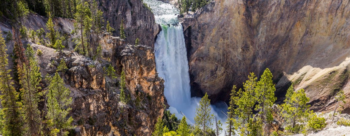
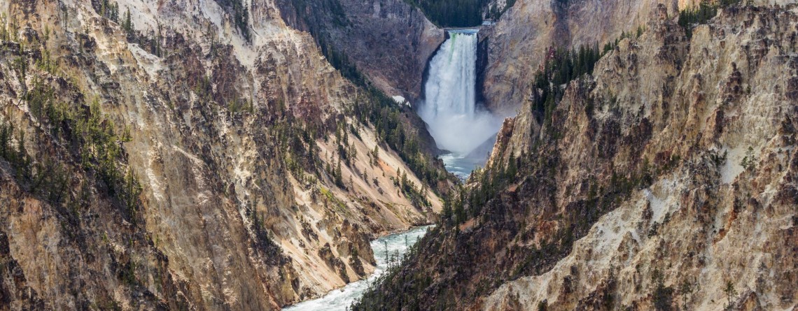
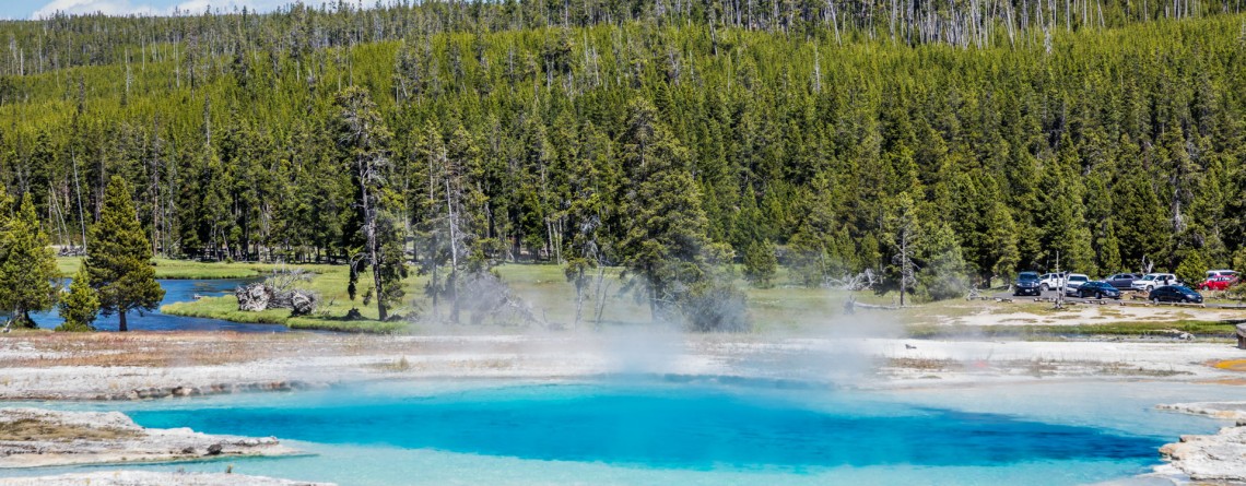
Uncle Tom’s Trail of the Grand Canyon in Yellowstone National Park

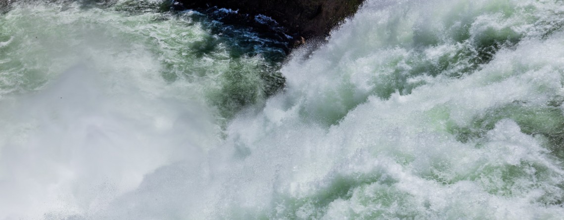
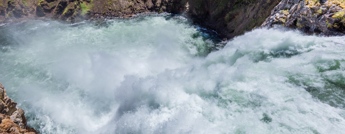
Location: Yellowstone National Park, Grand Canyon Area Distance: 0.6 miles (roundtrip) Elevation Gain: 373 ft GPS Coordinates: N 44 42.913 W 110 29.772 Uncle Tom’s Trail is fabulous and unusual trail that takes tourists from the top of Yellowstone’s Grand Canyon to the base of the biggest waterfall in Yellowstone to the 308-foot-high Lower Falls. Take these 328 steps down and enjoy the rainbow that is seen through the splashes and mist. Don’t worry that you won’t make it, you will because there are [...]

Brink of the Upper Falls in Yellowstone 8

Lower Falls – Power and Majesty. The Brink of the Lower Falls on the Grand Canyon of the Yellowstone National Park

Yellowstone Falls consist of two major waterfalls on the Yellowstone River: they are Upper and Lower Falls, both are separated by about a quarter mile, but you want be able to see the Lower Falls from the overlook atop the Upper Falls because of the bend of the Yellowstone River. The Grand Canyon of the Yellowstone Rivet takes its beginning at Upper Falls. This famous canyon is about 20 miles long, more than 1,000 feet deep, and 1,500 to 4,000 [...]

Brink of the Upper Falls 11

Brink of the Upper Falls on the Grand Canyon ib the Yellowstone National Park

Location: Yellowstone National Park Distance: 0.4 miles (roundtrip) Elevation change: 75 feet GPS Coordinates: N 44 42.874 W 110 30.042 The Grand Canyon of the Yellowstone Rivet takes its beginning at Upper Falls. Beautiful and panoramic views from the edge of this Nature’s masterpiece will take your breath away. Brink of the Upper Falls Trail provides fascinating views of the 109-foot waterfall with all its power. The Brink of the Upper Falls may be visited when you hike the North Rim Trail, but it [...]

Upper Geyser Basin 14

Upper Geyser Basin – home for the most famous geysers.

Location: Yellowstone National Park, Upper Geyser Basin GPS Coordinates: N 44 27.635 W 110 49.846 The Upper Geyser Basin is Yellowstone’s largest geyser basin and it has the highest concentration of hot springs in the world. The basin occupies the territory of about 1 mi2. This basin is home for the famous Old Faithful Geyser as well as for other numerous geothermal features. The whole day or even several can be spent here in exploration of this area, but please, follow general rules [...]

Back Basin - Norris Geyser Basin 18

Back Basin of Norris Geyser Basin – Yellowstone National Park

Location: Yellowstone National Park, Mammoth Hot Springs Length: 1.75 mile GPS Coordinates: N 44 43.567 W 110 42.117 The Norris Geyser Basin is the hottest geyser basin in Yellowstone National Park, one of its parts the Back Basin is considered to be more wooded and full of different geothermal features. Some people call this part “the land of extremes”. Tourist will see here the tallest geyser, but at the same time this geyser is infrequent, new and old geysers, springs that have been [...]

Boiling River Trail 34

Boiling River Trail

Location: Yellowstone National Park, Mammoth Hot Springs Length: 025 mile GPS Coordinates: N 44 59.557 W 110 41.496 Boiling River Trail is an interesting must-see and try destination in the Yellowstone National Park. A short 1.25-mile trail will take you to the Boiling River, a place where a large hot spring enters the Gardner River. The cold and hot water mixes here and becomes warm for bathing. Wear your bathing suit and enjoy this remarkable hot spring tub! Yellowstone’s Boiling River is located [...]

Artist Point, Yellowstone National Park 18

Artist Point on the Grand Canyon of the Yellowstone National Park

Location: Yellowstone National Park, Grand Canyon, South Rim Length: 0.1 mile GPS Coordinates: N 44 43.178 W 110 28.829 Artist Point on the Grand Canyon in the Yellowstone National Park offers fabulous views of the Yellowstone River and gorgeous canyons of light yellow and orange colors. Enjoy the views of the famous Lower Falls. It is truly a must-see and must-visit place in Yellowstone. The Grand Canyon itself is about 20 miles long; it was approximately measured from the Upper Falls to Tower Fall [...]

Midway Geyser Basin 25

Midway Geyser Basin and Grand Prismatic Spring and Excelsior Geyser

Location: Yellowstone National Park, Lower Geyser Basin Length: 0.8 miles GPS Coordinates:  N 44 31.705 W 110 50.175 Midway Geyser Basin is a small area known for the two big geothermal features that are located here. The size of the basin is small, but its popularity was won by the Excelsior Geyser and Grand Prismatic Spring. The basin itself is a part of Lower Geyser Basin, but because of its location it received a name of the Midway Geyser Basin. Grand Prismatic Spring is [...]

Artist's Paint Pots 27

Artist’s Paint Pots – Yellowstone National Park

Location: Yellowstone National Park Length: 1.1 miles GPS Coordinates: N 44 41.774 W 110 44.466 The Artist's Paint Pots trail is an easy and very popular hike featuring colorful hot springs, geysers, a fumaroles and mudpots in Yellowstone National Park. We encourage you to enjoy it in a natural setting. From the trailhead the trail takes you through a conifer forest. It should be mentioned that these trees were able to survive during the fire in 1988. After the forest the trail takes [...]

Old Faithful Geyser 2

Old Faithful Geyser – Is it really so faithful?

Location: Upper Geyser Basin, Yellowstone National Park GPS Coordinates: N 44 27.635 W 110 49.846 The Upper Geyser Basin in Yellowstone National Park is home for one of the most famous and faithful geysers in the world. This basin is famous for the fact that nearly one quarter of all worlds’ geysers is located here. Just imagine a territory in one square mile that has 150 geysers. Not only geysers, but also such thermal features like hot springs, boiling springs and [...]

Biscuit Basin 25

Biscuit Basin – Yellowstone National Park

Difficulty: Easy Length: 0.7 miles GPS Coordinates: N 44 29.103 W 110 51.153 Biscuit Basin is part of Upper Geyser Basin and is home for Mustard Spring, beautiful Sapphire Pool and Black Opal Pool, Shell Geyser, Avoca Spring, Jewel Geyser, etc. Biscuit Basic is located at Yellowstone National Park, only 3 miles from a very famous Old Faithful. The basin got its name thanks to the deposits, biscuit-shaped, that were found on the territory around Sapphire Pool. On August 17, 1959 the earthquake [...]

Salt Creek Interpretive Trail 21

Salt Creek Interpretive Trail. Incredible life in salty water.

Location: Death Valley National Park, Stovepipe Wells Area Length: ½ mile GPS Coordinates: N 36 35.436 W 116 59.433 Contact Information: Death Valley National Park P.O. Box 579 Death Valley, CA 92328 Salt Creek is a wonderful place in the Death Valley National Park. It is very unusual, because it’s hard to believe that in the desert you will find a real oasis full of life. If we talk about the trail itself, it is considered to be well-maintained and covered with wood boards. It’s not even a trail for [...]

Mosaic Canyon 16

Real Marble at Mosaic Canyon, Death Valley National Park

Location: Death Valley National Park, Stovepipe Wells Area Length: ½ - 2 miles GPS Coordinates: N 36 34.324 W 117 8.667 Contact Information: Death Valley National Park P.O. Box 579 Death Valley, CA 92328 Mosaic Canyon is one of the most scenic and beautiful sights in Death Valley national Park. The short trail will take you through the narrow canyon with high polished walls. Numerous floods have polished the marble walls and multicolored rock formations. Tourists will enjoy this hike with numerous opportunities to explore smooth marble walls. Mosaic Canyon [...]