Tag - amazing views

Painted Cove Trail 12

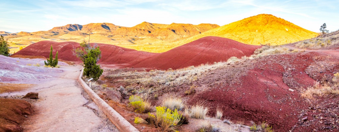
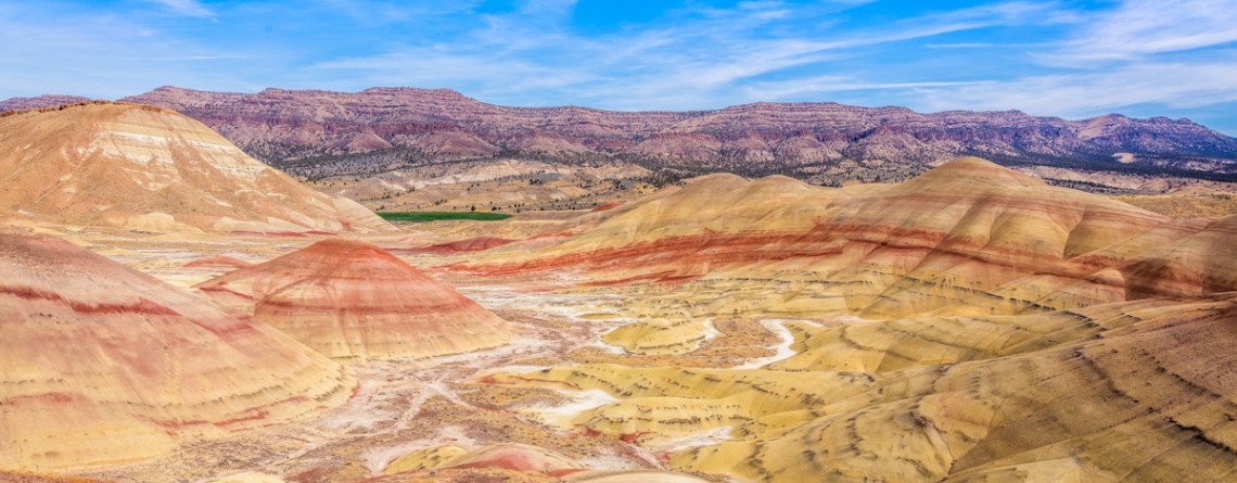
Unforgettable Experience with the Painted Cove Trail

Location: Painted Hills Unit, John Day Fossil Beds National Monument, Oregon Round Trip: 0,25 miles Difficulty: Easy Elevation Gain: 40 feet GRS Coordinates: N 44 39.723 W 121 43.278 Visitor’s Information Open: all year round No Pass Required Driving approximately 9 miles northwest from the town of Mitchell, Oregon, will bring you to the most beautiful, in our opinion, part of the John Day Fossil Beds National Monument – to Painted Hills Unit. The vibrant colors of its hills, the unreal beauty of its unique picturesque landscape draw the attention of people from [...]

Badwater Salt Flats 24

White Salt Flats of Badwater

Location: Death Valley National Park Length: 2 miles roundtrip GPS Coordinates: N 36 13.79 W 116 46.035 Contact Information: Death Valley National Park P.O. Box 579 Death Valley, CA 92328 Badwater Basin is an endorheic basin known as the lowest point in North America. Its elevation is 282 ft below sea level. The name to the area was given thanks to the spring-fed pool of “bad water”, the salt make this water undrinkable. Actually, this water is four times saltier than the water in the ocean. Although, the water in [...]

Natural Bridge Canyon Trail 17

Gorgeous Arch at Natural Bridge Canyon

Location: Death Valley National Park Length: 2 miles roundtrip GPS Coordinates: N 36 16.872 W 116 46.193 Natural Bridge Canyon Trail is one of the most popular in the Death Valley National Park. It is situated closely to Furnace Creek and is not very long. Only a 15-minute hike from the parking lot will take you to a 50-foot-high natural bridge. This arch is a result of erosion, and a great example of how it can create really huge holes in the stones. Natural Bridge Canyon [...]

Dante's View 23

Hiking around Death Valley: Dante’s View

Location: Death Valley National Park Elevation gain: 250-300 ft GPS Coordinates: N 36 13.238 W 116 43.584 Dante’s View is a fabulous overlook that is considered one of the best high elevations and easily-accessible viewpoints in California.  This viewpoint is situated at the edge of the Black Mountains and provides gorgeous views of southern part of Death Valley National Park. This place is considered to be one of the most photogenic places in the entire National Park. Thirteen-mile road leads you to Dante’s View, be prepared [...]

Carroll Rim Trail 64

The surreal views of the Carroll Rim Trail

Location: Painted Hills Unit, John Day Fossil Beds National Monument, Oregon Round Trip: 1,6 miles Difficulty: Moderate Elevation Gain: 400 feet GPS Coordinates: N 44 39.117 W 120 16.042 Visitor’s Information Open: all year round No Pass Required The Painted Hills Unit is one of three parts /units of the John Day Fossil Beds National Monument. And if the Clarno Unit is one of the most remote and the least visited one, the Painted Hills Unit is the most beautiful part of the National Monument. You don’t need to be scientist interested [...]

Coastal Trail, Hidden Beach Section 34

The Coastal Trail (Hidden Beach Section)

Location: Redwood National Park, California Round Trip: 7,8 miles Difficulty: Moderate Elevation Gain: 600 feet GPS Coordinates: N 41 35.632 W 124 05.913 Visitor’s Information Open: all year round No Pass Required   Worldwide known ancient redwood forests are not the only attraction the Redwood National and State Parks may offer to its visitors. A seventy-mile Coastal Trail provides the visitors with a change in redwoods hiking experience. It takes the hikers through the splendid coastal bluffs and solitary beaches of the Pacific coastline, opening for them amazing marine landscapes. And the most fascinating [...]

Skunk Cabbage Trail 15

Splendid Views of the Skunk Cabbage Trail

Location: Redwood National Park, California Round Trip: 10,5 miles Difficulty: Moderate Elevation Gain: 500 feet GPS Coordinates: N 41 35.671 W 124 05.981 Visitor’s Information Open: all year round No Pass Required Redwood National and State Parks are well-known among the tourists for the ancient redwood trees and magnificent forests, but the Coastal Trail, which occupies about 70 miles area, provides the hikers with a diverse experience. The Coastal Trail consists of a number of sections. The Skunk Cabbage Section (the Skunk Cabbage Trail) is one of them. The Skunk Cabbage Trail offers [...]

Emerald Ridge and Tall Trees 38

Emerald Ridge and Tall Trees Grove

Location: Redwood National Park, California Round Trip: 5,5 miles loop Difficulty: Moderate Elevation Gain: 700 feet GPS Coordinates: N 41 12.488 W 123 59.586 Visitor’s Information Open: only in summer during low water period Free permit is required for the gate The Tall Trees Grove is one of the most popular places among the visitors in the Redwood National and State Parks, even in spite of the fact that among all the attractions of the parks this one is the hardest to reach. For the grove protection from numerous visitors, especially during the [...]

Lady Bird Johnson Grove 8

Lady Bird Johnson Grove

Location: Redwood National Park, California Round Trip: 1,4 miles loop Difficulty: Easy Elevation Gain: 100 feet GPS Coordinates: N 41 18.209 W 124 01.079 Visitor’s Information Open: all year round No Pass Required Redwood National Park has quite a number of fantastic groves. One of the most popular among them is Lady Bird Johnson Gove as it’s not only an impressive natural feature of the park, but also a historical place. The Lady Bird Johnson trail was created for the ceremony of Redwoods National Park dedication, which happened on August 27, 1969. Many [...]

Berry Glen Trail 22

Falling in love: Berry Glen Trail, Redwood National and State Parks

Location: Redwood National Park, California Round Trip: 6 miles Difficulty: Moderate Elevation Gain: 1200 feet GPS Coordinates: N 41 19.440 W 124 02.621 Visitor’s Information No Pass Required The Berry Glen Trail is one of the newest elements of the Redwood National Park. Being opened in October, 2010, this trail is the first one built in the Redwood National Park within the last decade. Its creation became possible thanks to the help of the Civilian Conservation Corps. Now this well-built and well-maintained three-mile trail connects the Elk Meadow Day Use Area, [...]

North Kaibab Trail 12

Meeting the North Rim – North Kaibab Trail

Location: Grand Canyon, North Rim Round Trip: 28 miles Difficulty: Strenuous Elevation Change: 5,760 feet Highest Point: 8,241 feet (at the trailhead) GPS Coordinates: N 36 13.023 W 112 3.414 Visitor’s Information Open: mid. May – mid. October Planning to visit the Grand Canyon, you’ll have to decide first from which Rim to experience this breathtaking natural feature of Arizona State: South Rim, West Rim or North Rim. The North Rim is considered the least popular among tourists and hikers, but the reason for this is not the lack of picturesque views, scenic [...]

Horseshoe Bend 4

Horseshoe Bend

  Location: Near town of Page, Arizona State Round Trip: 1,5 miles Difficulty: Easy Elevation: 4,200 feet GPS Coordinates: N 36 52.571 W 111 30.16 Visitor’s Information Open: all year round Free Parking No Pass Required If you are visiting the Grand Canyon, or have just seen the Antelope Canyons and are moving further, looking for some more sightseeing, or maybe you are planning a trip to a beautiful Lake Powell, there is a side trip on your way, which you should definitely include into your plan. It will cost you nothing except for [...]

Bright Angel Point Trail 26

Unforgettable hike along Bright Angel Point Trail

Location: Grand Canyon, North Rim Round Trip: 0,5 miles Difficulty: Moderate Elevation Gain: 200 feet Highest Point: 8,148 feet GPS Coordinates: N 36 11.821 W 112 3.177 Visitor’s Information: Open mid. May – October, No Pass Required Bright Angel point is considered to be the most popular viewpoint among the visitors of the North Rim. A part of its popularity was earned, of course, due to its location. The trailhead or the Bright Angel Point Trail, leading to the viewing area, can be found just behind [...]