Travelling Blog

Smith Rock State Park 14

The Beauty of Smith Rock State Park

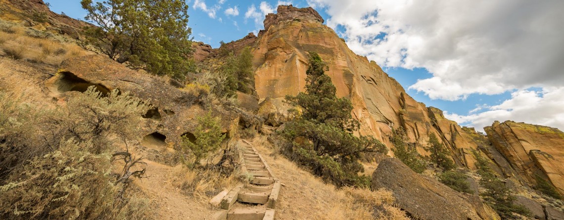
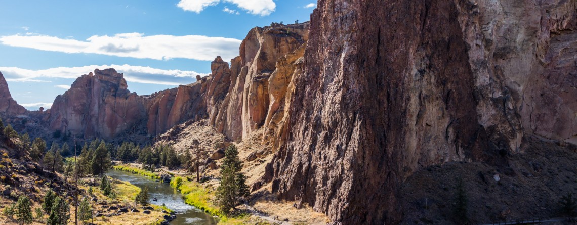
Address: Terrebonne, OR 97760, United States Phone number: 541-548-7501 Acreage: 651.68 Day-use: Fee Annual Pass: 24 month pass $5, $30, $50 GPS Coordinates: N 44 21.952 W 121 08.233 Smith Rock State Park is one of the pearls of Oregon State. Located on the banks of Crooked River, it spreads over the territory of 615 acres. Oregon State received the lands of this state park in the time period of 1960 - 1975 (some of them were donated, and some were bought by the state). Since then this incredible [...]

Mesa Verde Trail 15

Mesa Verde Trail at Smith Rock State Park

Location: Smith Rock State Park Length: 0.65 miles GPS Coordinates: N 44 21.952 W 121 08.233 Mesa Verde Trail is a very short, only 0.65-mile trail that connects to other more beautiful and popular trails. Though the trail is short and is used as a connecting trail, it provides several good views: nice views of Monkey Face and the surrounding. While hiking along this trail I was amazed by the numerous yellow rock, gorgeous views and fabulously beautiful sky. By the way, the [...]

Canyon Trail 13

Winding Canyon Trail

Location: Smith Rock State Park Length: 6.5 miles GPS Coordinates: N 44 21.952 W 121 08.233 Smith Rock State Park is a very interesting place, where you can explore and enjoy nature hiking, or look at the park from another prospective – climbing. Canyon Trail is an easy 1.5-mile trail, which at some point it becomes steeper. It winds around Crooked River and provides nice views of the park. This trail also allows hikers to enjoy forested area of the park, probably the only [...]

Burma Road Trail 19

Burma Road Trail: The View From Above

Location: Smith Rock State Park Length: 6.5 miles GPS Coordinates: N 44 21.952 W 121 08.233 Smith Rock State Park is a very popular destination in Oregon both among hikers and rock climbers. A well-developed trail system and numerous rocks for climbing attract thousands of tourists. Burma Road Trail is a breathtaking 6.5-mile hike that takes you to the top. The trail is fabulous because hikers see and explore the difference between the unique ecosystem near the river, at the bottom and at [...]

West Thumb Geyser Basin 13

West Thumb Geyser Basin, Yellowstone National Park

Location: Yellowstone National Park Length: less than a mile GPS Coordinates: N 44 24.941 W 110 34.419 West Thumb Geyser Basin is a popular destination among tourists because it sits right on the shore of Yellowstone Lake. This area was formed by a volcanic eruption thousands of years ago and is called the West Thumb caldera. It should be mentioned that this geyser basin is the largest one along the lake, most of geothermal features are located under the water of the lake. [...]

Porcelain Basin of Norris Geyser Basin 20

Porcelain Basin in Yellowstone National Park

Location: Yellowstone National Park Length: about a mile roundtrip GPS Coordinates: N 44 43.568 W 110 42.120 The Norris Geyser Basin is the hottest geyser basin in Yellowstone National Park. Some people call this part “the land of extremes”. Tourist will see here the tallest geyser, but at the same time this geyser is infrequent, new and old geysers, springs that have been damaged by people. We encourage you to follow the rules of the park and stay on specially designed trails. The [...]

Pelican ?reek Nature Trail 16

Pelican Creek Nature Trail

Location: Yellowstone National Park Length: 1 mile roundtrip GPS Coordinates: N 44 33.600 W 110 21.599 Pelican Creek Loop is very short trail that allows visitors to hike through the forest along the north bank of Yellowstone Lake, and at the same time enjoy the beauty of the shoreline. This is the path that offers panoramic, expansive views and fantastic opportunities for bird and wildlife watching. There are numerous birds on the lake and very often visitors may encounter bison grazing on the [...]

Mammoth Hot Spring in Yellowstone National Park

Location: Yellowstone National Park Length: 1.75 miles Elevation Gain: 300 feet GPS Coordinates: N 44 58.108 W 110 42.459 The Mammoth Hot Springs Terraces are very popular among the tourists and they have been popular since the very development of the Yellowstone National Park. The terraces were first described by the Hayden Survey in 1871 and they received a name of White Mountain Hot Spring. It should be said that Mammoth Terraces are changing their shape and color constantly. Very interesting thing happens when [...]

Wraith Falls 18

Wraith Falls in Yellowstone National Park

Location: Yellowstone National Park Length: 0.8 miles Elevation change: 120 feet GPS Coordinates: N 44 56.540 W 110 37.408 Yellowstone National Park is one of the greatest parks in US, it is very diverse and beautiful, featuring different geothermal features. This is the World?s First National Park that comprises the territory of 2,219,789 acres. The park is home to one of the world?s largest calderas with over 10,000 thermal features and more than 300 geysers. The park has 290 waterfalls and is home [...]

Calcite Springs Overlook 4

Calcite Springs Overlook in Yellowstone National Park

Location: Yellowstone National Park Length: 0.25 miles Elevation Gain: 25 feet GPS coordinates: N 44 54.109 W 110 23.586 Yellowstone is known for its gorgeous views and nature. This is the World’s First National Park that comprises the territory of 2,219,789 acres. The park is home to one of the world's largest calderas with over 10,000 thermal features and more than 300 geysers. The park has 290 waterfalls and is home for one of the largest petrifiied forests in the world. One of the [...]

Amazing sunset at Yellowstone National Park 9

Amazing Sunset at Yellowstone National Park

One of the most magical and gorgeous moment in a day is sunset. It’s the time when the day fades and the sun drowns in the endless horizon. Bright colors of the sky are just indescribable by words. John Lubbock said: “Sunsets are so beautiful that they almost seem as if we were looking through the gates of Heaven.” And this was a special sunset, the sky was colored in unbelievably beautiful and unearthly colors, it was the time to [...]

Fountain Paint Pots 23

Fountain Paint Pots in Yellowstone National Park

Location: Yellowstone National Park, Lower Geyser Basin Length: 0.7 miles GPS Coordinates: N 44 32.913 W 110 48.433 The Fountain Paint Pots Area is a must-visit destination in Yellowstone National Park that offers to explore all four kinds of geothermal features. Visitors will find here geysers, hot springs, pools, a fumarole and famous Fountain Paint Pot. The trail, leading to these geothermal features is an easy 0.7-mile trail, is good for all skill levels, and is accessible May-September. The Fountain Paint Post area [...]

Point Sublime, Yellowstone National Park 17

Point Sublime on the Grand Canyon of the Yellowstone National Park

Location: Yellowstone National Park, Grand Canyon Area Distance: 3 miles (roundtrip) Elevation gain: 250 feet GPS Coordinates: N 44 43.178 W 110 28.829 Point Sublime is one of the famous viewpoints on the south rim of the Grand Canyon in Yellowstone National Park. The overlook offers stunning views of the Yellowstone River and picturesque Grand Canyon itself. The trail is not very long, only 3 miles (roundtrip) with an elevation gain of 250 feet. The trail takes hikers along the edge of the canyon, [...]