Tag - USA

Natural Bridge Canyon Trail 17

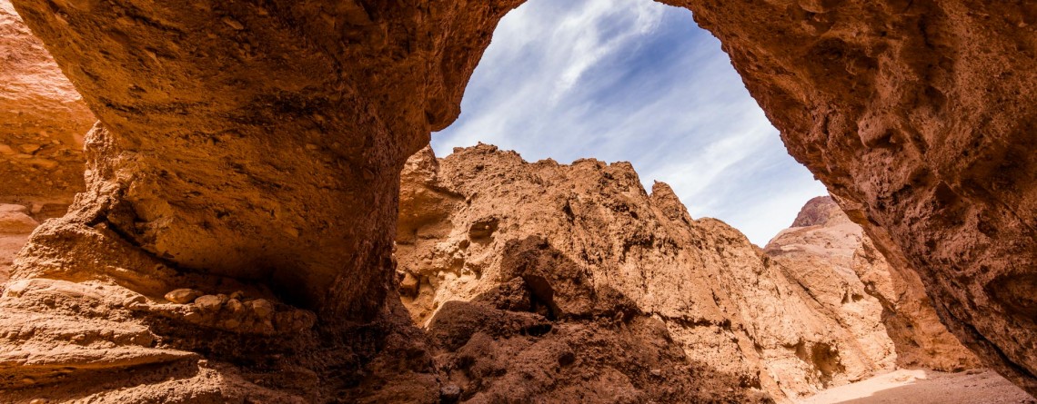
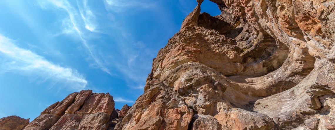
Gorgeous Arch at Natural Bridge Canyon

Location: Death Valley National Park Length: 2 miles roundtrip GPS Coordinates: N 36 16.872 W 116 46.193 Natural Bridge Canyon Trail is one of the most popular in the Death Valley National Park. It is situated closely to Furnace Creek and is not very long. Only a 15-minute hike from the parking lot will take you to a 50-foot-high natural bridge. This arch is a result of erosion, and a great example of how it can create really huge holes in the stones. Natural Bridge Canyon [...]

Arch Trail 29

Exploring the Clarno Unit: Arch Trail

Location: Clarno Unit, John Day Fossil Beds National Monument, Oregon Round Trip: 0,5 miles Difficulty: Moderate Elevation Gain: 200 feet GPS Coordinates: N 44 54.794 W 120 24.562 Visitor’s Information Open: all year round No Pass Required   Eastern part of Oregon will amaze you with a significant natural attraction - John Day Fossil Beds National Monument. This fantastic national monument introduces the visitors to the 40 million years evolution history of plants and animals, showing also the change of climate and various ecosystems which existed throughout all these millions of years. John Day [...]

Geologic Time Trail 26

50 Million Years’ History of the Geologic Time Trail

Location: Clarno Unit, John Day Fossil Beds National Monument, Oregon Round Trip: 0,5 miles Difficulty: Easy Elevation Gain: None GPS Coordinates: N 44 54.794 W 120 24.562 Visitor’s Information Open: all year round No Pass Required   The Geologic Time Trail is one of three Clarno Unit’s trails, allowing the visitors fully enjoy the striking Palisades and investigate the spectacular, unique fossils, telling us the story of the distant past, when Clarno Unit was not an arid, desert area, but a tropical forest full of various flora and fauna representatives. This trail provides [...]

Leaf Fossil Trail 31

The secret treasure of the Leaf Fossil Trail

Location: Painted Hills Unit, John Day Fossil Beds National Monument, Oregon Round Trip: 0,25 miles loop Difficulty: Easy GPS Coordinates: N 44 38.57 W 120 17.151 Visitor’s Information Open: all year round No Pass Required   At first glance the Leaf Fossil Trail (which is also known as the Leaf Hill Trail) may seem the least remarkable out of all trails meandering throughout the Painted Hills Unit. You will not find here the sweeping views or incredible panoramas of undulating, variegated hills of the unit. But this trail has something more [...]

Barnhouse Campground 4

Barnhouse Campground – the best campsite near Mitchell, OR

Location: Ochoco National Forest, Oregon Season: All year round Reservations: On “First Come, First Served” basis Phone Number: (541) 416-6500 GPS Coordinates: N44 28.077 W119 56.455 Visitor’s Information This is a free campground   Starting to plan a visit to John Day Fossil Beds National Monument, don’t forget to think about overnight possibilities beforehand. As camping is forbidden in the area of three units of the National Monument, one of the great options, which we highly recommend, is Barnhouse Campground. It’s quite close to Mitchell town. If you go east on Hwy 26 [...]

Carroll Rim Trail 64

The surreal views of the Carroll Rim Trail

Location: Painted Hills Unit, John Day Fossil Beds National Monument, Oregon Round Trip: 1,6 miles Difficulty: Moderate Elevation Gain: 400 feet GPS Coordinates: N 44 39.117 W 120 16.042 Visitor’s Information Open: all year round No Pass Required The Painted Hills Unit is one of three parts /units of the John Day Fossil Beds National Monument. And if the Clarno Unit is one of the most remote and the least visited one, the Painted Hills Unit is the most beautiful part of the National Monument. You don’t need to be scientist interested [...]

Trillium Falls Trail 9

Trillium Falls Trail – a real gem of the Redwood National Park

Location: Redwood National Park, California Round Trip: 2,8 miles loop Difficulty: Moderate Elevation Gain: 400 feet GPS Coordinates: N 41 19.440 W 124 02.621 Visitor’s Information Open: all year round No Pass Required The Trillium Falls Trail is one of the most popular trails in the Redwood National Park, and that is not only due to an easy access to it, but also to the features it is offering to its visitors. This 2,8 miles loop, which is one of the newest trails in the Park (finished in 2002) will take you [...]

Berry Glen Trail 22

Falling in love: Berry Glen Trail, Redwood National and State Parks

Location: Redwood National Park, California Round Trip: 6 miles Difficulty: Moderate Elevation Gain: 1200 feet GPS Coordinates: N 41 19.440 W 124 02.621 Visitor’s Information No Pass Required The Berry Glen Trail is one of the newest elements of the Redwood National Park. Being opened in October, 2010, this trail is the first one built in the Redwood National Park within the last decade. Its creation became possible thanks to the help of the Civilian Conservation Corps. Now this well-built and well-maintained three-mile trail connects the Elk Meadow Day Use Area, [...]

Lookout Mountain Rd

Interesting facts about Lookout Mountain Road, Baker County, Oregon

Location: Baker County, Oregon Length: about 17 miles GPS Coordinates: N 44 28.491 W 117 20.478 Visitor’s Information Open: all year round No Pass Required Sometimes vanity and excessive pace of a big city is exhausting us so much that it seems nothing can please us any more, favorite work doesn't provide any sense of accomplishment, and even family brings to our life only irritation instead of joy and happiness... The main thing is to understand at the right time that it's a point in your life to [...]

North Kaibab Trail 12

Meeting the North Rim – North Kaibab Trail

Location: Grand Canyon, North Rim Round Trip: 28 miles Difficulty: Strenuous Elevation Change: 5,760 feet Highest Point: 8,241 feet (at the trailhead) GPS Coordinates: N 36 13.023 W 112 3.414 Visitor’s Information Open: mid. May – mid. October Planning to visit the Grand Canyon, you’ll have to decide first from which Rim to experience this breathtaking natural feature of Arizona State: South Rim, West Rim or North Rim. The North Rim is considered the least popular among tourists and hikers, but the reason for this is not the lack of picturesque views, scenic [...]

Trail of Time 5

Breathtaking Trail of Time

Location:    Grand Canyon, South Rim Round Trip:    2,83 miles Difficulty:    Easy GPS Coordinates:    N 36 3.969 W 112 7.055 Visitor’s Information:    Open all year round, No Pass Required Magnificent and fascinating Grand Canyon astonished and attracted people for hundreds of years. But in spite of all uniqueness and incredible geologic history of Grand Canyon, there was no any program showing, teaching or explaining its geologic significance on a worldwide scale, until in 2007 Yavapai Observation station was rededicated as a Geology Museum, and [...]