Tag - views

Burma Road Trail 19

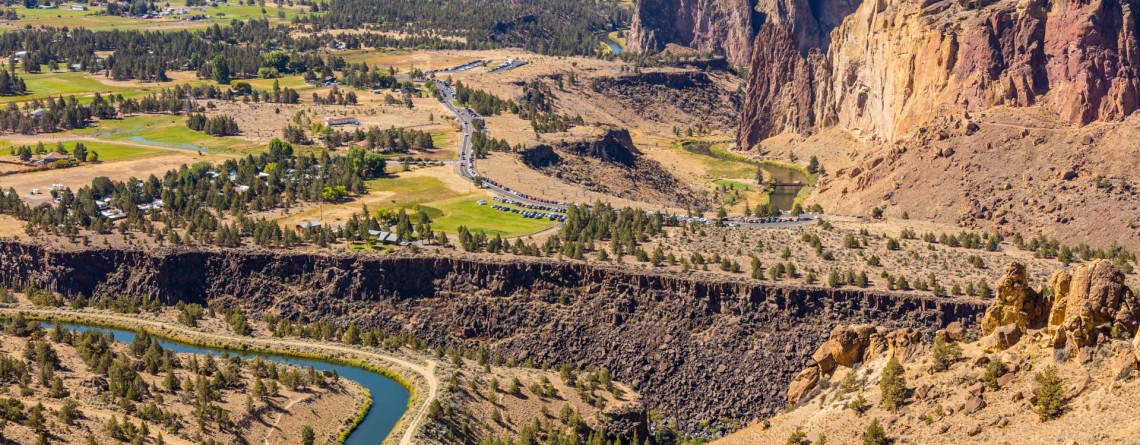
Burma Road Trail: The View From Above

Location: Smith Rock State Park Length: 6.5 miles GPS Coordinates: N 44 21.952 W 121 08.233 Smith Rock State Park is a very popular destination in Oregon both among hikers and rock climbers. A well-developed trail system and numerous rocks for climbing attract thousands of tourists. Burma Road Trail is a breathtaking 6.5-mile hike that takes you to the top. The trail is fabulous because hikers see and explore the difference between the unique ecosystem near the river, at the bottom and at [...]

Mammoth Hot Spring in Yellowstone National Park

Location: Yellowstone National Park Length: 1.75 miles Elevation Gain: 300 feet GPS Coordinates: N 44 58.108 W 110 42.459 The Mammoth Hot Springs Terraces are very popular among the tourists and they have been popular since the very development of the Yellowstone National Park. The terraces were first described by the Hayden Survey in 1871 and they received a name of White Mountain Hot Spring. It should be said that Mammoth Terraces are changing their shape and color constantly. Very interesting thing happens when [...]

Amazing sunset at Yellowstone National Park 9

Amazing Sunset at Yellowstone National Park

One of the most magical and gorgeous moment in a day is sunset. It’s the time when the day fades and the sun drowns in the endless horizon. Bright colors of the sky are just indescribable by words. John Lubbock said: “Sunsets are so beautiful that they almost seem as if we were looking through the gates of Heaven.” And this was a special sunset, the sky was colored in unbelievably beautiful and unearthly colors, it was the time to [...]

Point Sublime, Yellowstone National Park 17

Point Sublime on the Grand Canyon of the Yellowstone National Park

Location: Yellowstone National Park, Grand Canyon Area Distance: 3 miles (roundtrip) Elevation gain: 250 feet GPS Coordinates: N 44 43.178 W 110 28.829 Point Sublime is one of the famous viewpoints on the south rim of the Grand Canyon in Yellowstone National Park. The overlook offers stunning views of the Yellowstone River and picturesque Grand Canyon itself. The trail is not very long, only 3 miles (roundtrip) with an elevation gain of 250 feet. The trail takes hikers along the edge of the canyon, [...]

Brink of the Upper Falls 11

Brink of the Upper Falls on the Grand Canyon ib the Yellowstone National Park

Location: Yellowstone National Park Distance: 0.4 miles (roundtrip) Elevation change: 75 feet GPS Coordinates: N 44 42.874 W 110 30.042 The Grand Canyon of the Yellowstone Rivet takes its beginning at Upper Falls. Beautiful and panoramic views from the edge of this Nature’s masterpiece will take your breath away. Brink of the Upper Falls Trail provides fascinating views of the 109-foot waterfall with all its power. The Brink of the Upper Falls may be visited when you hike the North Rim Trail, but it [...]

Biscuit Basin 25

Biscuit Basin – Yellowstone National Park

Difficulty: Easy Length: 0.7 miles GPS Coordinates: N 44 29.103 W 110 51.153 Biscuit Basin is part of Upper Geyser Basin and is home for Mustard Spring, beautiful Sapphire Pool and Black Opal Pool, Shell Geyser, Avoca Spring, Jewel Geyser, etc. Biscuit Basic is located at Yellowstone National Park, only 3 miles from a very famous Old Faithful. The basin got its name thanks to the deposits, biscuit-shaped, that were found on the territory around Sapphire Pool. On August 17, 1959 the earthquake [...]

Salt Creek Interpretive Trail 21

Salt Creek Interpretive Trail. Incredible life in salty water.

Location: Death Valley National Park, Stovepipe Wells Area Length: ½ mile GPS Coordinates: N 36 35.436 W 116 59.433 Contact Information: Death Valley National Park P.O. Box 579 Death Valley, CA 92328 Salt Creek is a wonderful place in the Death Valley National Park. It is very unusual, because it’s hard to believe that in the desert you will find a real oasis full of life. If we talk about the trail itself, it is considered to be well-maintained and covered with wood boards. It’s not even a trail for [...]

Mosaic Canyon 16

Real Marble at Mosaic Canyon, Death Valley National Park

Location: Death Valley National Park, Stovepipe Wells Area Length: ½ - 2 miles GPS Coordinates: N 36 34.324 W 117 8.667 Contact Information: Death Valley National Park P.O. Box 579 Death Valley, CA 92328 Mosaic Canyon is one of the most scenic and beautiful sights in Death Valley national Park. The short trail will take you through the narrow canyon with high polished walls. Numerous floods have polished the marble walls and multicolored rock formations. Tourists will enjoy this hike with numerous opportunities to explore smooth marble walls. Mosaic Canyon [...]

Mesquite Falls Sand Dunes 46

Unusual Mesquite Flat Sand Dunes – Death Valley National Park

Location: Death Valley National Park Length: No trail GPS Coordinates: N 36 36.372 W 117 6.904 Contact Information: Death Valley National Park P.O. Box 579 Death Valley, CA 92328 Mesquite Flat Sand Dunes are beautiful and the most accessible sand dunes in Death Valley. Though they are not the tallest, they are very popular among tourists. The largest dune is called Star Dune. The highest dune rises about 100 feet, but these dunes cover massive territory, but it’s only one percent of the Death Valley that is covered with [...]

Devil's Golf Course 18

Devil’s Golf Course – Alien Views and Landscape

Location: Death Valley National Park Length: It can be as long as you want (there is no a designated trail) GPS Coordinates: N 36 17.157 W 116 49.567 Contact Information: Death Valley National Park P.O. Box 579 Death Valley, CA 92328 The Devil’s Golf Course is a fabulously beautiful and large salt pan on the floor of Death Valley National Park. It is located in the Mojave Desert. This salt pen is a huge bed of a dried up Lake Manly that covered the territory of the valley. The [...]

Golden Canyon 53

Vibrant colors at Golden Canyon

Location: Death Valley National Park Length: 2 miles roundtrip GPS Coordinates: N 36 25.24 W 116 50.812 Contact Information: Death Valley National Park P.O. Box 579 Death Valley, CA 92328 Golden Canyon is an easy hike, it can be only a 2-mile hike (roundtrip) to Red Cathedral Junction, or the hike can be longer, if you decide to continue to Gower Gulch or even Zabriskie Point. Very often tourists ask when the best time to hike Death Valley National Park is. We recommend hiking between October and April. Even in [...]

Artist's Drive 46

Unusual Color Palette: Artist’s Drive and Artist’s Palette

Location: Death Valley National Park Area: Furnace Creek GPS Coordinates:  N 36 19.798 W 116 49.792 Artist’s Drive, as well as famous Artist’s Palette, is located in the Black Mountains on the territory of Death Valley National Park. This is a scenic drive (one way road) that takes visitors through the colorful area. Artist’s Drive is a nine-mile road that travels from south to north. It ascends above the salt flat of Badwater and opens impressive, fabulous and unforgettable views. This road carves through the high [...]

Zabriskie Point 15

Dramatic views and geological history – Zabriskie Point, Death Valley National Park

Location:    Death Valley National Park, Furnace Creek Area Round Trip:    2.9 miles from Golden Canyon GPS Coordinates:    N 36 25.258 W 116 48.578 Death Valley National Park is a 3.4 million acre park that is the largest park in the contiguous states of the USA.  This unusual valley is surrounded by steep mountain ranges. There are the Panamint Mountains to the west, and the Black, Funeral, and Grapevine Mountains to the east. Its highest point is Telescope Peak, at 11,049 feet. Death Valley [...]