Tag - hiking

Hatton Trail 22

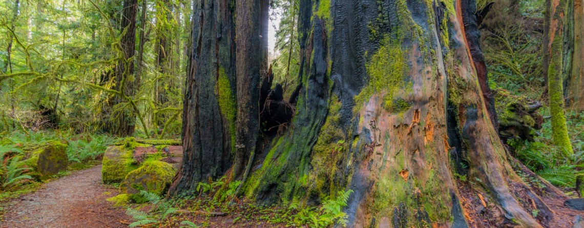
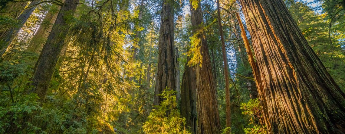
An amazing diversity of woodland shown by the Hatton Trail

  Location: Jedediah Smith Redwoods State Park, California Length: 4,3 miles Difficulty: Moderate Elevation gain: 360 feet GPS coordinates: N 41 48.692 W124 06.388 The Hatton Trail is one of the well-favoured routes giving a chance to explore Jedediah Smith Redwoods State Park. Moreover, this is three-in-one trail described here, as it combines the Hatton Loop, the Hatton Trail itself and a short spur-trail to Lohse Grove. The trail is located on the southern side of Highway 199, and can be accessed from two flanks: you may [...]

Boy Scout Tree Trail 3

Boy Scout Tree Trail – an incredible journey amidst titanic trees

  Location: Jedediah Smith Redwoods State Park, California Length: 5,3 miles Difficulty: Moderate Elevation gain: 750 feet GPS coordinates: N 41 46.098 W124 06.624 A beautiful Jedediah Smith Redwoods State Park (or Jed Smith, as it is called among the hikers), is the northern section of the Redwood National and State Parks, containing 7% of the primeval redwood forests, which are left in the whole world. And the ultimate way to get a deep feel of this amazing place is to hike the Boy Scout Tree Trail. Nowadays [...]

Heron Pond / Swan Lake Loop 16

Heron Pond / Swan Lake Loop Trail of Grand Teton National Park

    Location: Grand Teton National Park, Wyoming Length: 3 miles Difficulty: Easy Elevation gain: 300 feet GPS coordinates: N 43 54.031   W 110 38.533   Grand Teton National Park is special among all US national parks. Most of its rivers and lakes got their names as a result of expeditions in 1872. It is also the only national park of all, where there is an airport. The numerous lakes of the park attract a great diversity of waterfowl, and the height and beauty of its [...]

Christian Pond Loop 17

Amazing autumn scenery of Christian Pond Loop

  Location: Grand Teton National Park, Wyoming Length: 3,3 miles Difficulty: Easy Elevation gain: 400 feet GPS coordinates: N 43 52.691   W 110 34.363 Grand Teton National Park - a speck of untouched pristine nature just south of Yellowstone National Park, in northwest Wyoming. The park is well-known and beloved by tourists for its fascinating views of the mountains, shimmering of pure alpine lakes and abundant wildlife. Its highest peak, Grand Teton, rises up to almost 14,000 feet a.s.l. and the park spreads over [...]

The Watchman Trail 6

Unforgettable Views of the Watchman Trail

Location: Zion National Park, Utah Length: 3 miles (with the loop at the end of the trail) Ascent: 300 feet Difficulty: Easy GPS Coordinates:  N 37 12.083   W 112 59.186   The start of this 3-mile long trail can be found near the Visitor’s Center, you just need to cross the Route 9 to find yourself at its trailhead. It is interesting that regardless of its proximity to Park’s South Entrance, this trail is missed by lots of visitors, who prefer more popular routes like [...]

The Narrows 10

The Narrows – an incredibly unique experience for any hiker!

Location: Zion National Park, Utah Length: as long as you wish Difficulty: Moderate GPS Coordinates: N 37 17.798  W 112 56.895   Zion Narrows is among the most incredible and breathtaking adventures in the US. Thousands of people come to Zion National Park in order to challenge themselves with this scenic and adventurous hike. This unique hike at the bottom of a sandstone canyon, the walls of which rise thousands of feet vertically and come as close as twenty feet across at some places is [...]

East Mesa Trail 11

East Mesa Trail (going to Observation Point)

  Location: Zion National Park, Utah Length: 3,3 miles (one way trip) Elevation Gain: 280 feet Difficulty: Moderate GPS Coordinates: N  37 17.819   W  112 54.013 Zion National Park has several overlooks providing the visitors with an amazing panorama of the park’s canyons. One of them is Observation Point, situated at the Eastern Rim of Zion Canyon, at elevation of approximately 6,500 feet. The usual starting point for the hikers, willing to reach Observation Point, is the Weeping Rock Trailhead, which is actually the start [...]

Riverside Walk Trail 24

Riverside Walk Trail at Zion National Park

  Location: Zion National Park, Utah Length: 2 miles roundtrip Ascent: 57 feet Difficulty: Easy GPS Coordinates: N 37 17.058 W 112 56.811 The Riverside Walk Trail is an outstanding and fascinating trek in Zion National Park, presenting for the park visitors the breathtaking views of immense stone walls of Zion Canyon as seen from its very bottom, and marvelous views of the Virgin River, flowing along the trail. It’s amazing but the quantity of the trail visitors in summer months reaches three thousand per [...]

Sand Bench Horse Trail 22

Sand Bench Trail – the underestimated gem of Zion National Park

Location: Zion National Park, Utah Length: 3,5 mile Elevation gain: 440 feet GPS coordinates: N 37 14.239 W 112 57.745 The Sand Bench Horse Trail is one of the trails of Zion National Park, which probably has the most contradictory reviews of the visitors who decided to explore it. The beauty and uniqueness of the views offered by this trail is undeniable. Approximately seven thousand years have passed since a part of one of the most famous Zion peaks – The Sentinel – collapsed, [...]

Emerald Pools Trail 15

Emerald Pools Trail – a Green Oasis in the Desert of Zion National Park

  Location: Zion National Park, Utah Length: approximately 3 miles – roundtrip to the Upper Pool GPS coordinates: N 37 15.066 W 112 57.551   Emerald Pools can be called a signature place, a fascinating oasis in the desert of Zion National Park. They were given such a name for their unusual color. During some periods of time of the year algae provides the water in the pools with such a unique hue. A series of basins were carved into a rock ledge of [...]

Summit Trail 11

Summit Trail at Smith Rock State Park – unforgettable views

Address: Terrebonne, OR 97760, United States Phone number: 541-548-7501 Length: 2 miles GPS Coordinates: N 44 21.952 W 121 08.233 The Summit Trail is the youngest trail in the park, which was opened in 2013. It is actually a connecting trail and is usually hiked as a part of Summit Trail Loop which starts at the parks’ Welcome Center and runs for approximately 7, 5 miles throughout the Smith Rock State Park, and includes Canyon Trail, River Trail, Summit Trail, Burma Road Trail and Wolf [...]

Rope de Dope Trail 16

Interesting Rope de Dope Trail at Smith Rock State Park

Address: Terrebonne, OR 97760, United States Phone number: 541-548-7501 Length: 0.5 miles GPS Coordinates: N 44 21.952 W 121 08.233 This short trail, stretching forward for only 0.5 miles, is regarded to be one of the most often used trails and one of the major connectors between the trails within the well-conceived trail system of incredible Smith Rock State Park. For people staying at The Bivy (the campground area) Rope de Dope trail arranges an access to the Canyon Trail, leading to the footbridge across the [...]

River Trail 27

Amazing River Trail at Smith Rock State Park

Address: Terrebonne, OR 97760, United States Phone number: 541-548-7501 Length: 0.68 miles GPS Coordinates: N 44 21.952 W 121 08.233 Information Center: Crooked River National Grassland, 274 SW 4th Street, Madras, OR River Trail is an extremely easy picturesque trail, especially popular and often visited by families with kids and various age visitors, who are eager to enjoy all the beauty of Smith Rock State Park without climbing the strenuous trails, preferring a pleasant saunter at a leisurely pace. To find to the River Trail from the [...]