Tag - breathtaking scenery

Fountain Paint Pots 23

Fountain Paint Pots in Yellowstone National Park

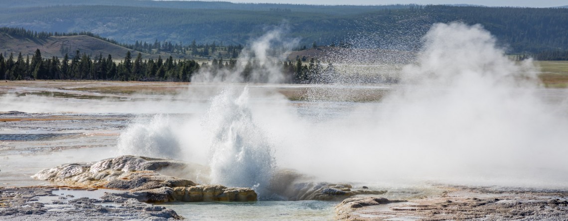
Location: Yellowstone National Park, Lower Geyser Basin Length: 0.7 miles GPS Coordinates: N 44 32.913 W 110 48.433 The Fountain Paint Pots Area is a must-visit destination in Yellowstone National Park that offers to explore all four kinds of geothermal features. Visitors will find here geysers, hot springs, pools, a fumarole and famous Fountain Paint Pot. The trail, leading to these geothermal features is an easy 0.7-mile trail, is good for all skill levels, and is accessible May-September. The Fountain Paint Post area [...]

Brink of the Upper Falls in Yellowstone 8

Lower Falls – Power and Majesty. The Brink of the Lower Falls on the Grand Canyon of the Yellowstone National Park

Yellowstone Falls consist of two major waterfalls on the Yellowstone River: they are Upper and Lower Falls, both are separated by about a quarter mile, but you want be able to see the Lower Falls from the overlook atop the Upper Falls because of the bend of the Yellowstone River. The Grand Canyon of the Yellowstone Rivet takes its beginning at Upper Falls. This famous canyon is about 20 miles long, more than 1,000 feet deep, and 1,500 to 4,000 [...]

Midway Geyser Basin 25

Midway Geyser Basin and Grand Prismatic Spring and Excelsior Geyser

Location: Yellowstone National Park, Lower Geyser Basin Length: 0.8 miles GPS Coordinates:  N 44 31.705 W 110 50.175 Midway Geyser Basin is a small area known for the two big geothermal features that are located here. The size of the basin is small, but its popularity was won by the Excelsior Geyser and Grand Prismatic Spring. The basin itself is a part of Lower Geyser Basin, but because of its location it received a name of the Midway Geyser Basin. Grand Prismatic Spring is [...]

Old Faithful Geyser 2

Old Faithful Geyser – Is it really so faithful?

Location: Upper Geyser Basin, Yellowstone National Park GPS Coordinates: N 44 27.635 W 110 49.846 The Upper Geyser Basin in Yellowstone National Park is home for one of the most famous and faithful geysers in the world. This basin is famous for the fact that nearly one quarter of all worlds’ geysers is located here. Just imagine a territory in one square mile that has 150 geysers. Not only geysers, but also such thermal features like hot springs, boiling springs and [...]

Biscuit Basin 25

Biscuit Basin – Yellowstone National Park

Difficulty: Easy Length: 0.7 miles GPS Coordinates: N 44 29.103 W 110 51.153 Biscuit Basin is part of Upper Geyser Basin and is home for Mustard Spring, beautiful Sapphire Pool and Black Opal Pool, Shell Geyser, Avoca Spring, Jewel Geyser, etc. Biscuit Basic is located at Yellowstone National Park, only 3 miles from a very famous Old Faithful. The basin got its name thanks to the deposits, biscuit-shaped, that were found on the territory around Sapphire Pool. On August 17, 1959 the earthquake [...]

Salt Creek Interpretive Trail 21

Salt Creek Interpretive Trail. Incredible life in salty water.

Location: Death Valley National Park, Stovepipe Wells Area Length: ½ mile GPS Coordinates: N 36 35.436 W 116 59.433 Contact Information: Death Valley National Park P.O. Box 579 Death Valley, CA 92328 Salt Creek is a wonderful place in the Death Valley National Park. It is very unusual, because it’s hard to believe that in the desert you will find a real oasis full of life. If we talk about the trail itself, it is considered to be well-maintained and covered with wood boards. It’s not even a trail for [...]

Golden Canyon 53

Vibrant colors at Golden Canyon

Location: Death Valley National Park Length: 2 miles roundtrip GPS Coordinates: N 36 25.24 W 116 50.812 Contact Information: Death Valley National Park P.O. Box 579 Death Valley, CA 92328 Golden Canyon is an easy hike, it can be only a 2-mile hike (roundtrip) to Red Cathedral Junction, or the hike can be longer, if you decide to continue to Gower Gulch or even Zabriskie Point. Very often tourists ask when the best time to hike Death Valley National Park is. We recommend hiking between October and April. Even in [...]

Red Scar Knoll Trail 16

Red Scar Knoll Trail – the Beauty of Oregon’s Desert

Location: Painted Hills Unit, John Day Fossil Beds National Monument, Oregon Round Trip: 0,5 miles Difficulty: Easy Elevation Gain: Minimal GRS Coordinates: N 44 38.137 W 120 17.555 Visitor’s Information Open: all year round No Pass Required Amazingly beautiful Painted Hills Unit of the Oregon’s John Day Fossil Beds National Monument can fairly be called a natural wonder. Its uniqueness, astonishing colors and stunning undulating forms will make you to feel like you are visiting a Fairyland or another planet (hiking the Painted Cove Trail will surely give you the sensation of a spaceman [...]

Dante's View 23

Hiking around Death Valley: Dante’s View

Location: Death Valley National Park Elevation gain: 250-300 ft GPS Coordinates: N 36 13.238 W 116 43.584 Dante’s View is a fabulous overlook that is considered one of the best high elevations and easily-accessible viewpoints in California.  This viewpoint is situated at the edge of the Black Mountains and provides gorgeous views of southern part of Death Valley National Park. This place is considered to be one of the most photogenic places in the entire National Park. Thirteen-mile road leads you to Dante’s View, be prepared [...]

Artist's Drive 46

Unusual Color Palette: Artist’s Drive and Artist’s Palette

Location: Death Valley National Park Area: Furnace Creek GPS Coordinates:  N 36 19.798 W 116 49.792 Artist’s Drive, as well as famous Artist’s Palette, is located in the Black Mountains on the territory of Death Valley National Park. This is a scenic drive (one way road) that takes visitors through the colorful area. Artist’s Drive is a nine-mile road that travels from south to north. It ascends above the salt flat of Badwater and opens impressive, fabulous and unforgettable views. This road carves through the high [...]

Bright Angel Trail, South Rim 68

Bright Angel Trail – the Premiere Trail of the Grand Canyon

Location: Grand Canyon, South Rim Round Trip: 19 miles Difficulty: Strenuous Elevation Change: 4,380 feet Highest Point: 6,860 feet (at the trailhead) GPS Coordinates: N 36 3.432 W 112 8.623 Visitor’s Information All year round   The Bright Angel Trail is one of the three trails of the Grand Canyon, which lead to the very Colorado River. Two others are the South Kaibab Trail and the North Kaibab Trail. But the Bright Angel Trail is considered to be in the greatest demand and is the most heavily used trail of the Grand Canyon. And [...]

Painted Hills Overlook Trail 14

The Best Views of the Painted Hills Overlook Trail

Location: Painted Hills Unit, John Day Fossil Beds National Monument, Oregon Round Trip: 0,5 miles Difficulty: Easy Elevation Gain: 100 feet GPS Coordinates: N 44 38.997 W 120 16.005 Visitor’s Information Open: all year round No Pass Required   One more option to enjoy some really scenic views of the Painted Hills and get the most out of this incredible area is hiking the Painted Hills Overlook Trail. It’s much shorter than the Carroll Rim Trail, but the fabulous views it opens for its visitors are highly competitive with those of the Carroll [...]